Devil's Chimney (Isle of Wight)
For other landscape features of the same name see Devil's Chimney (disambiguation).
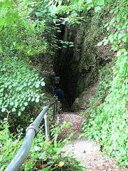
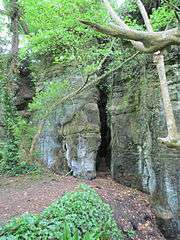
The Devil's Chimney is a scenic rock cleft with steps descending into the Bonchurch Landslips between Bonchurch and Luccombe, Isle of Wight.
Its upper end is at the Smuggler's Haven Tearooms on St Boniface Down,[1] at the southern end of clifftop parkland accessed from the Leeson Road car park on the A3055 road, where there is a Southern Vectis bus route 3 stop.
One of several such paths connecting the clifftop to the Isle of Wight Undercliff, the Devil's Chimney follows a joint through the Upper Greensand crags capping the cliffs above the Landslip.[2] The path continues down through the Landslip as footpath V65C,[3] meeting the coastal path V65A at its foot.
A similar rock cleft, the Chink, is about 200 yards north.
References
Coordinates: 50°36′19.34″N 1°10′51.25″W / 50.6053722°N 1.1809028°W