Dietzenley
| Dietzenley | |
|---|---|
|
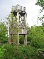
Viewing tower on the Dietzenley | |
| Highest point | |
| Elevation | 617.6 m above sea level (NHN) (2,026 ft) [1] |
| Coordinates | 50°12′09″N 6°40′40″E / 50.2025°N 6.67778°ECoordinates: 50°12′09″N 6°40′40″E / 50.2025°N 6.67778°E |
| Geography | |
 Dietzenley Vulkaneifel county, Rhineland-Palatinate, Germany | |
| State/Province | DE-RP |
| Parent range | Volcanic Eifel |
| Geology | |
| Mountain type |
Basalt volcano |
The Dietzenley in the county of Vulkaneifel in the German state of Rhineland-Palatinate is a mountain, 617.6 m above sea level (NHN),[1] and the highest point in the Pelm Forest, a part of the Volcanic Eifel range.
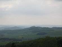
View of the Alter Voß from the tower
The Dietzenley rises within the Volcanic Eifel Nature Park in the parish of Gerolstein north and above the Gerolstein quarter of Büscheich-Niedereich.
On the largely wooded domed summit stands a small, wooden observation tower, which offers a good view of the Volcanic Eifel. Somewhat below it there is an electrical convertor and the remains of a Celtic ringwall.
The Dietzenley may be reached on footpaths from Gerolstein, Pelm or Gees.
References
- 1 2 Map service of the Landscape Information System of the Rhineland-Palatinate Nature Conservation Office (Naturschutzverwaltung Rheinland-Pfalz)
This article is issued from Wikipedia - version of the 10/17/2016. The text is available under the Creative Commons Attribution/Share Alike but additional terms may apply for the media files.