Division of Bradfield
| Bradfield Australian House of Representatives Division | |
|---|---|
|
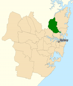
Division of Bradfield in New South Wales, as of the 2016 federal election. | |
| Created | 1949 |
| MP | Paul Fletcher |
| Party | Liberal |
| Namesake | John Bradfield |
| Electors | 105,735 (2016) |
| Area | 101 km2 (39.0 sq mi) |
| Demographic | Inner Metropolitan |
The Division of Bradfield is an Australian electoral division in the state of New South Wales. The division was created in 1949 and is named in honour of Dr John Bradfield,[1] the designer of the Sydney Harbour Bridge.
The electorate is located in the upper North Shore and covers an area of approximately 99 km2, covering the suburbs Castle Cove, East Killara, East Lindfield, Gordon, Killara, Lindfield, North Turramurra, North Wahroonga, Pymble, Roseville, Roseville Chase, South Turramurra, St Ives, St Ives Chase, Turramurra, Wahroonga, Waitara, Warrawee, and West Pymble; as well as parts of Asquith, Chatswood, Chatswood West, Hornsby, Mount Colah, and Normanhurst.
The current Member for Bradfield, since the 2009 Bradfield by-election, is Paul Fletcher, a member of the Liberal Party of Australia.
History and demographics
Bradfield was created in the 1949 expansion of Parliament. Its first member was Billy Hughes, a former Prime Minister of Australia and the last serving member of the first federal Parliament. The bulk of the seat was carved out of North Sydney, which Hughes represented from 1923 to 1949. After Hughes, its best-known member was Brendan Nelson, a minister in the third and fourth Howard Governments and the federal Leader of the Opposition from 2007 to 2008.
Located in the traditional Liberal stronghold of Sydney's North Shore, Bradfield has been in Liberal hands for its entire existence, and for most of that time has been reckoned as a very safe Liberal seat.[2] Indeed, for many years it was the safest Coalition seat in metropolitan Australia. After the 2013 federal election, Bradfield became the second-safest, behind neighboring Mitchell, with a 20 percent swing required for Labor to win it.[3] However, as of the 2016 federal election, Bradfield is once again the safest metropolitan Coalition seat, with a 21-point swing needed for Labor to win it.
As at the 2011 Census, households within the Division of Bradfield had the highest level of median weekly household income of any electorate in Australia.[4]
Members
| Member | Party | Term | |
|---|---|---|---|
| Billy Hughes | Liberal | 1949–1952 | |
| Harry Turner | Liberal | 1952–1974 | |
| David Connolly | Liberal | 1974–1996 | |
| Brendan Nelson | Liberal | 1996–2009 | |
| Paul Fletcher | Liberal | 2009–present | |
Election results
| Party | Candidate | Votes | % | ± | |
|---|---|---|---|---|---|
| Liberal | Paul Fletcher | 57,231 | 61.12 | −3.96 | |
| Labor | Katie Gompertz | 15,926 | 17.01 | +0.42 | |
| Greens | Adrian Jones | 10,936 | 11.68 | −1.15 | |
| Independent | Christine Berman | 4,248 | 4.54 | +4.54 | |
| Christian Democrats | Chris Vale | 3,497 | 3.73 | +1.91 | |
| Liberty Alliance | Peter Kelly | 1,796 | 1.92 | +1.92 | |
| Total formal votes | 93,634 | 96.45 | +2.16 | ||
| Informal votes | 3,446 | 3.55 | −2.16 | ||
| Turnout | 97,080 | 91.81 | −3.48 | ||
| Two-party-preferred result | |||||
| Liberal | Paul Fletcher | 66,513 | 71.04 | +0.10 | |
| Labor | Katie Gompertz | 27,121 | 28.96 | −0.10 | |
| Liberal hold | Swing | +0.10 | |||
References
- ↑ "Profile of the electoral division of Bradfield (NSW)". Australian Electoral Commission. 22 February 2012. Retrieved 6 April 2012.
- ↑ Green, Antony (2010). "Bradfield". Australia votes 2010. Australian Broadcasting Corporation.
- ↑ "Bradfield, NSW". Election 2013. Australian Electoral Commission. 27 September 2013. Retrieved 6 November 2013.
- ↑ http://mumble.com.au/fedelect13/wall/censustables/MEDINC.HTM
- ↑ Bradfield, NSW, Virtual Tally Room 2016, Australian Electoral Commission.
External links
Coordinates: 33°43′55″S 151°08′46″E / 33.732°S 151.146°E
