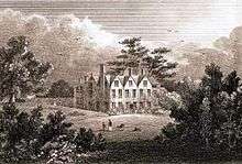
Duffield Hall

Duffield Hall is a 17th-century country house situated in the Amber Valley, Derbyshire and the former headquarters of the Derbyshire Building Society. It is a Grade II* listed building.[1]
The manor of Duffield was granted by King Charles I to the Newton family who built a new mansion house there in the 1620s. The Newtons sold the house to Henry Coape, High Sheriff of Derbyshire in 1703. His granddaughter and heiress brought the estate to her husband Henry Porter.
In the early 19th century he left the property to his kinsman Thomas Porter Bonell whose daughter married Sir Charles H Colville. After Colville's death the house was sold to John Bell Crompton of Milford (High Sheriff in 1847) a Banker of Irongate, Derby. He died in 1860 and the estate was acquired by Rowland Smith. Member of Parliament for South Derbyshire 1868-74 and High Sheriff 1877.

Smith extensively restored and improved the house creating the present mansion of three storeys and five gabled bays.
From 1908 until 1970 the house and estate was occupied by St Ronan's School.[2] The girls' school closed in 1970 and in 1977 the property was acquired by the Derbyshire Building Society for whom it was restored and extended by architects George Grey and Partners. Much of the adjoining estate was sold for the residential development of St Ronans Road.
In 2013 planning permission was granted for a change of use to a single dwelling house, (B1 Office to C3 Residential) demolition of later additions and a private swimming pool, together with a mix of 9 Bungalows and Courtyard Houses [3]
References
- ↑ Historic England. "Duffield Hall (Grade II*) (1158301)". National Heritage List for England. Retrieved 11 December 2015.
- ↑ Derbyshire Life and Country, August 1965
- ↑ Amber Valley Planning Application
- Magna Britannia. Vol 5 Derbyshire (1817) p127. Gentry families of Derbyshire from British History Online
- English Heritage, Images of England. Photograph and detailed architectural description
- Magna Britannia. Vol 5 Derbyshire (1817). Manor of Duffield from British History Online
Coordinates: 52°59′00″N 1°29′14″W / 52.9833°N 1.4871°W