Duni, Assam
| Duni দুনী | |
|---|---|
| Town | |
|
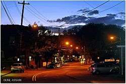
View of Dipila-Borichowka Road in Duni, Assam | |
 Duni  Duni Location in Assam | |
| Coordinates: 26°28′11″N 91°50′38″E / 26.469689°N 91.843979°ECoordinates: 26°28′11″N 91°50′38″E / 26.469689°N 91.843979°E | |
| Country | India |
| State | Assam |
| Region | Upper Assam |
| District | Darrang |
| Zone | 1 (Central) |
| Duni Gaonpanchayat | 1909 |
| Founded by | Government of Assam |
| Government | |
| • Body | Duni Town Committee |
| Elevation | 116 m (381 ft) |
| Languages | |
| • Official | Assamese |
| Time zone | IST (UTC+5:30) |
| PIN | 784148[1] |
| Vehicle registration | AS-13 |
| Planning agency | 1 |
| Climate | Semi-Arid (Köppen) |
| † Estimated as on 2012 | |
Duni is an urban village of Sipajhar tehsil, Darrang district, Assam, India.[1] It is one of major place in darrang district. It is in the west part of the district. the place Cultural Center of Darrang region.
Education
| SL No. | School | Type |
|---|---|---|
| 1 | Duni Higher Secondary School | Governmental |
| 2 | Duni College, Dolonghat | Governmental |
| 3 | Bherua L.P School | Governmental |
| 4 | Pachim Darrang Jatiya Vidyalaya | Non-Governmental |
| 5 | Mahoripara L.P School | Governmental |
References
| Wikimedia Commons has media related to Duni, Assam. |
- 1 2 "Duni Village". OneFiveNine.com. Retrieved 1 February 2014.
This article is issued from Wikipedia - version of the 10/26/2016. The text is available under the Creative Commons Attribution/Share Alike but additional terms may apply for the media files.
