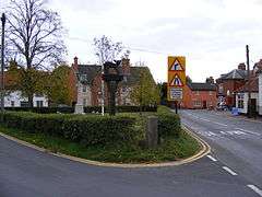
East Harling
Coordinates: 52°26′24″N 0°55′51″E / 52.44011°N 0.93076°E
East Harling is a village in the English county of Norfolk. The village forms the principal settlement in the civil parish of Harling (where the population is included), and is located some 8 miles (13 km) east of the town of Thetford and 25 miles (40 km) south-west of the city of Norwich.[1]
The village is served by Harling Road railway station, which is situated 2 miles (3 km) to the north.
From 1808 to 1814 East Harling hosted a station in the shutter telegraph chain which connected the Admiralty in London to its naval ships in the port of Great Yarmouth.
References
- ↑ Ordnance Survey (1999). OS Explorer Map 230 - Diss & Harleston. ISBN 0-319-21862-7.
External links
| Wikimedia Commons has media related to East Harling. |
- Map sources for East Harling
- Information from Genuki Norfolk on East Harling.
This article is issued from Wikipedia - version of the 10/2/2016. The text is available under the Creative Commons Attribution/Share Alike but additional terms may apply for the media files.

