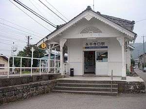
Eiheijiguchi Station
Eiheijiguchi Station 永平寺口駅 | |
|---|---|
 Eiheijiguchi Station | |
| Location |
9 Higashi-Furuichi, Eiheiji, Yoshida, Fukui (福井県吉田郡永平寺町東古市9) Japan |
| Operated by | Echizen Railway |
| Line(s) | Katsuyama Eiheiji Line |
| Connections |
|
| History | |
| Opened | 1914 |
| Previous names | Eiheiji; Higashi-Furuichi (until 2003) |
Eiheijiguchi Station (永平寺口駅 Eiheijiguchi-eki) is a railway station on the Katsuyama Eiheiji Line in Eiheiji, Fukui, Japan, operated by the private railway operator Echizen Railway.
Station layout
All Katsuyama Eiheiji Line trains serve Eiheijiguchi Station. Two platforms serve three tracks, and the station is staffed. The station building is the original structure from 1914.[1]
History
- February 11, 1914: Eiheiji Station opens.
- September 16, 1925: Eiheiji Railway opens Eiheijiguchi — Eiheijimon-Mae section.
- April 26, 1926: Through trains from Shin-Fukui to Eiheijimon-Mae begin operating.
- January 1, 1927: Station renamed to Eiheijiguchi Station.
- December 10, 1929: Eiheiji Railway Kanazu (now Awaraonsen) — Eiheijiguchi section opens.
- December 1, 1944: Line transferred to Keifuku Electric Railway. Station renamed Higashi-Furuichi Station.
- September 18, 1969: Kanazu — Higashi-Furuichi section closed.
- December 17, 2000: Two trains collide just east of the station due to a brake malfunction.
- June 25, 2001: Operations halted due to a second accident on the Echizen Main Line.
- October 21, 2001: Eiheiji — Higashi-Furuichi section closed.
- February 20, 2003: Station renamed to Eiheijiguchi Station.
- July 20, 2003: Station reopens as an Echizen Railway station.
Surrounding area
- This station is the closest to the Zen Buddhist temple Eihei-ji. Visitors transfer to Keifuku or Eiheiji community buses at the stop in front of the station.
- Other points of interest include:
- Eiheiji Town Hall, Eiheiji Branch Office
- National Route 364
- National Route 416
- Kuzuryū River
References
| Wikimedia Commons has media related to Eiheijiguchi Station. |
- ↑ 私鉄史ハンドブック(和久田康雄 著、電気車研究会、1993年) Private Railway History Handbook, Denkishakenkyukai, 1993.
Coordinates: 36°05′45″N 136°19′36″E / 36.095825°N 136.32679°E
This article is issued from Wikipedia - version of the 12/23/2015. The text is available under the Creative Commons Attribution/Share Alike but additional terms may apply for the media files.