Elliptical Road
| Elliptical Road | |
|---|---|
| QMC Road | |
|
The Elliptical Road in 2015 | |
| Location | |
| Quezon City | |
| Roads at junction: |
Commonwealth Avenue Quezon Avenue Visayas Avenue North Avenue East Avenue Maharlika Street Kalayaan Street |
| Construction | |
| Type: | Roundabout |
| Lanes: | 8 |
| Map | |
 | |
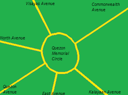
The Elliptical Road is a large 2-km Roundabout[1] and Landmark in Quezon City which circumscribes the Quezon Memorial Circle. It was named after its elliptical shape. The spinning in this roundabout is in a counterclockwise direction. The road is divided into 8 lanes, wherein 3 are the main lanes, 4 lanes are for exiting vehicles with one lane for bicycles and pedicabs.
Land Marks and Government Offices
- Quezon Memorial Circle
- Quezon Memorial Monument
- Department of Agrarian Reform [2]
- Department of Agriculture [3]
- Ninoy Aquino Parks and Wildlife Center
- Agricultural Training Institute
- Philippine National Bank
- Quezon City Hall
- Quezon City Hall of Justice
- Philippine Coconut Authority[4]
- People's Television Network Headquarters
Junctions
The Elliptical Road serves as a terminus of 7 major Quezon City thoroughfares, the Commonwealth Avenue, the Quezon Avenue, the North Avenue, the East Avenue, the Visayas Avenue, the Maharlika Street and the Kalayaan Avenue.[5]
Commonwealth Avenue
The Commonwealth Avenue is an 18-lane highway that goes to the Holy Spirit, Balara and Batasan Districts of Quezon City. It is also a route heading to Novaliches and Bulacan Province. This is the first junction of the Elliptical Road. Most vehicles on the Elliptical Road comes from this road.
Visayas Avenue
Is an 8-lane road heading to the Project 6 District. It leads to the Central Avenue, Congressional Avenue, Tandang Sora Avenue, Luzon Avenue and Mindanao Avenue. The Department of Agrarian Reforms and the Department of Agriculture are located near this junction.
North Avenue
Is an 8-lane thoroughfare leading to the North Triangle District and the Triangle Park Industrial Center, where the SM City north EDSA and Trinoma Malls are located. This road goes to the northern part of EDSA that goes to NLEX, Caloocan, and Monumento.[6]
Quezon Avenue
Quezon Avenue is an 8-lane highway leading to EDSA, Welcome Rotunda and Manila. The Ninoy Aquino Parks and wildlife are located near this junction.
East Avenue
Is a 6-lane highway that leads to the East Triangle and EDSA. This road goes to the southern parts of EDSA that goes to Cubao, Mandaluyong, Makati and Pasay. Several hospitals including the Philippine Heart Center, East Avenue Medical Center and National Kidney and Transplant Institute and government offices, like PAGASA Central Office, Land Transportations Office, and the Central Bank of the Philippines are located in this road.
Maharlika Street
Leads to Commonwealth Avenue.
Kalayaan Avenue
Is a 6-lane thoroughfare leading to Kamias, Socorro and Cubao Districts.
See also
- Quezon City
- Triangle Park
- Major Roads in Metro Manila
- Quezon Avenue
- Epifanio De los Santos Avenue
- Quezon Memorial Circle
- Commonwealth Avenue, Quezon City
References
- ↑ http://maps.google.com.ph/maps?q=elliptical%20road&hl=tl&biw=1366&bih=667&um=1&ie=UTF-8&sa=N&tab=wl
- ↑ http://www.dar.gov.ph/.../IARCDSP%20Vacancy%2
- ↑ http://www.da.gov.ph
- ↑ http://www.pca.da.gov.ph/
- ↑ Metro Manila Map
- ↑ ikimapia.org/16905704/North-Ave-Elliptical-Road-Junction
Coordinates: 14°38′59″N 121°2′50″E / 14.64972°N 121.04722°E