Elthorne Hundred
Coat of arms of Middlesex County Council
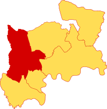
Location of Elthorne Hundred within Middlesex.
Elthorne was a hundred (ancient subdivision) of the ancient county of Middlesex, England. It covered the western part of the county and contained the following parishes and settlements:[1]
- Cowley
- Cranford
- Greenford
- Hanwell
- Harefield
- Harlington
- Harmondsworth
- Hayes
- Hillingdon
- Ickenham
- New Brentford
- Northolt
- Norwood
- Perivale
- Ruislip
- Uxbridge
- West Drayton
Its territory roughly corresponded to the present London Borough of Hillingdon, plus the west of the London Borough of Ealing.
References
- ↑ "Table Of Population 1801–1901". British History. Retrieved 1 May 2011.
Coordinates: 51°32′N 0°24′W / 51.54°N 0.40°W
This article is issued from Wikipedia - version of the 1/25/2015. The text is available under the Creative Commons Attribution/Share Alike but additional terms may apply for the media files.