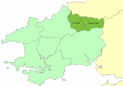
Emlyn
Coordinates: 52°01′59″N 4°26′06″W / 52.033°N 4.435°W

Emlyn was one of the seven cantrefi of Dyfed, an ancient district of Wales. It became part of Deheubarth in around 950. It consisted of the northern part of Dyfed bordering on the River Teifi. Its southern boundary followed the ridge of the line of hills separating the Teifi valley from the valleys of the Tâf and Tywi.[1]
The name derives from am (around, on both sides of) and glyn (valley), the valley in question being presumably the Cuch.[2] Its area was about 217 km2. It was divided by the River Cuch into the commotes of Emlyn Is Cuch (to the west) and Emlyn Uwch Cuch to the east. Its civil headquarters were divided between Cilgerran in the lower commote and Newcastle Emlyn in the upper. Its ecclesiastical centre (and perhaps, in the Age of the Saints, the seat of a bishop[3]) was the church of St Llawddog at Cenarth.
The cantref was made part of the Norman March in the 12th century, and many castles were built, including those of Cilgerran and Newcastle Emlyn. Nevertheless, the area remained Welsh speaking, as it continues today.
At the time of the Acts of Union, the cantref was split between the newly formed counties, when Emlyn Is Cuch became Cilgerran hundred, Pembrokeshire and Emlyn Uwch Cuch was merged into Elfed hundred, Carmarthenshire. Its name lives on in several local placenames, including Newcastle Emlyn.
Notes
- ↑ Richards, Melville, Welsh Administrative and Territorial Units, UoW Press, 1969, p 268
- ↑ Charles, B. G., The Placenames of Pembrokeshire, National Library of Wales, Aberystwyth, 1992, ISBN 0-907158-58-7, p 347
- ↑ Williams, A. H., An Introduction to the History of Wales: Volume I: Prehistoric Times to 1063, UoWP, 1941, pp 120-121