Empresa de Ferrocarriles Ecuatorianos

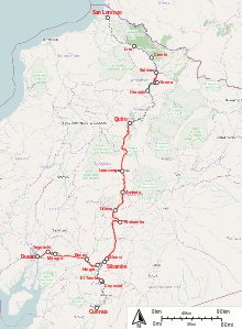
━━━ Routes with passenger traffic
━━━ Routes in usable state
·········· Unusable or dismantled routes
The Ferrocarriles del Ecuador Empresa Publica (FE EP) (Ecuadorian Railways Company) is the national railway of Ecuador. The railway system was devised to connect the Pacific coast with the Andean highlands. After many decades of service the railway was severely damaged by heavy rainfall during the El Niño in 1997 and 1998[1][2] and from general neglect as the Pan-American Highway siphoned off passengers.[2][3]
In 2008 the president Rafael Correa named the railroad a "national cultural patrimony"[2] and indicated that it would be restored. The government of Ecuador started to rehabilitate the railway and service was restored between Guayaquil and Quito by 2013.[4]
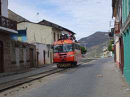
Tourist trains and railbusses (autoferros) are running from Quito via Cotopaxi national park to Latacunga, between Alausi to Sibambe (Devil's Nose / Nariz del Diablo), between El Tambo and Baños del Inca, between Duran and Yaguachi and between Ibarra and Salinas.
Construction

The project of an Ecuadorian railway was started by President Gabriel García Moreno in 1861. The first section was opened between Durán and Milagro in 1873, and Bucay was reached by 1888.[5]
The push into the Andes was made under President Eloy Alfaro who planned to link Quito in the highlands to Guayaquil on the coast of Ecuador. For advice, Alfaro turned to Col. William Findlay Shunk, a well-known North American engineer who designed the New York El, and who had mapped a route of the InterContinental Railway (which was to connect North and South America) through Ecuador, Colombia, and Panama in 1892. The InterContinental Railway was never built. However, in 1897, Eloy Alfaro commissioned a contract with Archer Harman and a team of investors for the newly created New Jersey corporation, the Guayaquil and Quito Railway Company," or the G&Q, to rehabilitate and complete the railroad from Guayaquil to Quito. Archer Harman and his brother, Major John A. Harman (Col. Shunk's son-in-law) were from Staunton, Virginia. Together, Archer (G&Q financier) and John (G&Q Chief Engineer) helped Alfaro to (1) realize his dream of connecting disparate parts of Ecuador, (2) break the hold of the Catholic Church, and (3) usher the 20th Century and modernity into Ecuador.
The G&Q Rwy line was built between 1897 and 1908,[2] when the line reached Quito amidst celebration that lasted for days, and shortened the often lengthy trip from Quito to Guayaquil to two days.
The G&Q Rwy line evolved into the Southern Division (Division Sur) of Empresa de Ferrocarriles Ecuatorianos (EFE).
Operation

The railway represents the largest infrastructure of the country with a total length of 965.5 kilometres (600 mi). Its single track uses a gauge of 3 ft 6 in (1,067 mm). The 446.7 kilometres (277.6 mi) Southern Division (Division Sur) starts at the harbour of Guayaquil with a ferry to Duran and then heads east into the Andean mountains where a more than 2.5 kilometres (8,200 ft) difference in altitude has to be overcome to reach Riobamba at 2,754 metres (9,035 ft). A major gain in altitude is made at the Devil's Nose (Nariz del Diablo) where the train shunts back and forth along the rocky promontory. From Riobamba the train heads north passing its highest point at Urbina an altitude of 3,609 metres (11,841 ft) to reach Quito at an altitude of 2,850 metres (9,350 ft).
The 373.4 kilometres (232.0 mi) Northern Division (Division Norte) was completed in 1957.[5] It connects Quito to the northern sea port of San Lorenzo over Ibarra, Primer Paso and Cachavi.
The Cuenca line branches off near Sibambe and represents the 145.4 kilometres (90.3 mi) Subdivision Sur. It was constructed between 1915 and 1965.[5]

The railway used to be of general economic significance for many decades. Initially steam engines were obtained from the Baldwin Locomotive Works. The last set of 2-8-0 steam engines were obtained in 1953.[5] In 1957 the first Alstom diesel-electric engines were delivered, later engines were delivered in 1968, and again in 1992. The last delivery consisted of Alstoms AD24 BBB with the numbers 2401-9. Few steam and diesel engines are in an operational mode and numbers of availability conflict.[1][5] Also a number of railbusses (autoferros) are part of EFE.
Demise
Since the 1997/98 disruptions no continuous service has been conducted and further degradation has made the railway almost useless. Road services have taken over passenger and freight transportation in Ecuador. At the 2008 centennial only 10 percent of the railway was open [2] only tourist trains remain active.
Restoration
In 2008 the president Rafael Correa named the railroad a "national cultural patrimony"[2] and indicated that it would be restored. The EFE was transformed in a public corporation: Ferrocarriles del Ecuador Empresa Publica (FEEP) The first section which was reopened, was from Riobamba to Urbina(1:see table), which now is only used for charter service. In 2009 a small section of the side branch to Cuenca from El Tambo to Baños del Inca(2) was reopened.[6] In 2010 the Quito - Latacunga(3) - Section restarted service after restoration.[7] At the coast the section between Duran near Guayaquil and Yaguachi(4) was reopened in 2010.[8] Also the section Alausí - Sibambe(5) which entails the switchback at the Devil's Nose was repaired by 2011.
The section Riobamba - Alausí(6) and the section Riobamba - Urbina - Ambato(7) were restored in 2011.[9] According to a contract the Spanish narrow gauge railway company FEVE three of the Alstoms AD24 BBB will be repaired in Spain.[10]
By 2013 the Guayaquil/Duran - Quito railway was restored and open to the public.[11]
Southern Division (Division Sur)
Guayaquil <> Quito; 1897-1908; 446.7 km (277.6 mi)
| Place | Reached | Details | Situation |
|---|---|---|---|
| Guayaquil | ? | ||
| ferry | ferry | ||
| Durán | 1873 | ||
| + 2010 (4) = restored 2010, see (4) above | |||
| Yaguachi | 1873? | ||
| 2010 | |||
| Milagro | 1873 | ||
| ? | |||
| Bucay | 1888 | ||
| ? | |||
| Sibambe | 2011 | ||
| Devil's Nose | + (5) | ||
| Alausí | ? | branch line: > Azogues > Cuenca ( Subdivision Sur; Alausí <> Cuenca; 1915-1965; 145.4 km (90.3 mi); El Tambo to Baños del Inca: + 2009 (2) ) | |
| + 2011 (6) | |||
| Riobamba | 2011 | ||
| + 2011 (1+6) | |||
| Urbina | ? | highest point ( 1°30′01″S 78°43′59″W / 1.500321°S 78.733177°W ) | |
| + 2011 (7) | |||
| Ambato | ? | ||
| ? | |||
| Latacunga | ? | ||
| + 2010 (3) | |||
| Machachi | ? | ||
| + 2010 (3) | |||
| Quito | 1908 |
Northern Division (Division Norte)
Quito <> San Lorenzo; > 1957; 373.4 km (232.0 mi)
| Place | Reached | Details | Situation |
|---|---|---|---|
| Quito | 1908 | ||
| ? unknown | |||
| Cayambe | ? | ||
| ? | |||
| Ibarra | ? | ||
| ? | |||
| Primer Paso | ? | ||
| ? | |||
| Cachavi | ? | San Javier de Cachavi ( 1°03′58″N 78°46′38″W / 1.066111°N 78.777222°W ) | |
| ? | |||
| San Lorenzo | ? |
There are plans to expand the services further to Colombia and Venezuela.
- On the Malecon in Guayaquil
.jpg) Switchback at the Devil's Nose
Switchback at the Devil's Nose- Riobamba railway station
- Railway poster, Riobamba station
Books
- Elizabeth Harman Brainard and Katharine Robinson Brainard. Railroad in the Sky: the Guayaquil & Quito Railway in Ecuador 1897-1925. Publisher: Marion, MA: Atlantis Ltd. Partnership, 2003. ISBN 0-615-12411-9 ISBN 9780615124117
- Marcelo Meneses-Jurado: Tren al Sol. Train to the Sun. Journey on Board the Most Difficult Train in the World.
References
- 1 2 "Plan para rehabilitar ferrocarril". El Universo. June 30, 2005. Retrieved March 23, 2009.
- 1 2 3 4 5 6 Mark Holston. "Remnants of an intercontinental railway: considered one of the most difficult engineering tasks in the world, the Guayaquil-Quito Railroad continues to inspire awe and admiration 100 years after its completion". Retrieved March 23, 2009.
- ↑ Haines, Gavin, "Ecuador’s long-neglected railway system chugs back to life; its founder Eloy Alfaro would be proud," Cuenca High Life, 3 June 2013. Retrieved 8 May 2016.
- ↑ De Quito a Durán, en tren desde el 2012, promete EFE, El Universo, December 23rd 2009.
- 1 2 3 4 5 ferrolatino. "Aus der Geschichte der Eisenbahn in Ecuador". Retrieved March 23, 2009.
- ↑ http://www.eluniverso.com/2009/04/18/1/1447/7EDE4067B8F140409EDE18B4C55646F6.html El Universo, April 18th 2009.
- ↑ http://www.elcomerciodelecuador.es/component/content/article/71/834-el-tren-quito-latacunga-vuelve-por-la-avenida-de-los-volcanes.html El Comercio November 26th 2010
- ↑ http://www4.elcomercio.com/2010-07-01/Noticias/Pais/Noticias-Secundarias/EC100701P15PAPA.aspx El Comercio, July 1st 2010.
- ↑ http://www.diariolosandes.com.ec/content/view/23926/36/ Diaro Del Los Andes, December 23rd 2010
- ↑ http://www.hoy.com.ec/noticias-ecuador/ecuador-surcara-el-atlantico-para-recuperar-sistema-ferroviario-453232.html Hoy January 15th 2010
- ↑ Ecuador by Train
External links
| Wikimedia Commons has media related to Rail transport in Ecuador. |
- New official website
- Railroad in the Sky website
- Ecuador's railway in the sky (The Daily Telegraph)
- Official site (Spanish)
- 2003 travel pictures from the Devil's Nose by Peter & Jackie Main
- 2005 pictures, Riobamba to Mocha
- Train stations and altitude profile between Guayaquil and Quito
- Full tour pictures 2005
- UN Map