Farm to Market Road 1
| ||||
|---|---|---|---|---|
 | ||||
| Route information | ||||
| Maintained by TxDOT | ||||
| Length: | 18.640 mi[1] (29.998 km) | |||
| Existed: | 1941[1] – present | |||
| Major junctions | ||||
| South end: |
| |||
|
| ||||
| North end: |
| |||
| Location | ||||
| Counties: | Sabine, San Augustine | |||
| Highway system | ||||
| ||||

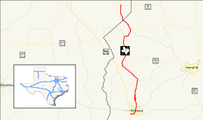
Farm to Market Road 1 (FM 1), is a farm-to-market road, a state maintained road which serves to connect rural and agricultural areas to market towns, in the U.S. state of Texas. The road was the first farm-to-market road to be designated in Texas at the request of local industry for a paved road. The 18.6-mile (29.9 km) road provides access to rural areas of East Texas from U.S. Highway 96.
History
The road was designated on April 23, 1941, the first Farm to Market Road to be designated in Texas. It was designated shortly after it was upgraded from a dirt road to a paved road at the request of The Temple Lumber Company and two gas companies.[2] It wasn't until eight years later that legislation to establish the farm-to-market road system was passed.[2] FM 1 originally ran from Pineland northward to Magasco from its inception in 1941 until October 13, 1954 when FM 1776, which began at SH 184, was cancelled and combined with FM 1. Also, FM 1 was rerouted and its old route became a spur connection to Magasco.[1] Throughout its history, the road has predominantly served the logging industry.[2]
Route description
FM 1 begins in southwestern Sabine County near Pineland at a junction with U.S. Highway 96.[1] In Pineland, FM 1 is known as Temple Avenue and travels eastward and then northward through the town. North of Pineland, the road's name changes to Magasco Drive as it travels northward to the town of Magasco. Just south of Magasco, FM 1 has a short spur that travels on the west side of the BNSF Railway tracks as the main road crosses the tracks and parallels the spur to the east of the tracks.[3]
FM 1 continues northward through Sabine County then turns to a more northwesterly route after its junction with FM 2024. FM 1 is known as North Temple Road as it enters the town of Bronson. A short break occurs in the road as it intersects SH 184 in Bronson. FM 1 begins again at a point farther north on SH 184 and heads north as Bronson Road.[3]
FM 1 heads north from Bronson until it intersects with SH 103 west of Rosevine. At this point another break in the road occurs. FM 1 begins again at a point farther east along SH 103. The road heads to the northeast and is known as Rosevine Road. The road changes course to the north-northwest after a junction with FM 1592. FM 1 leaves Sabine County northwest of Rosevine. Only a couple of miles of FM 1 are existence in San Augustine County. The road enters the northeastern portion of the county heading north until it terminates at State Highway 21 at Fords Corner.[1][3]
Major intersections
| County | Location | mi[3] | km | Destinations | Notes |
|---|---|---|---|---|---|
| Sabine | Pineland | 0.0 | 0.0 | Southern terminus | |
| 0.7 | 1.1 | ||||
| 1.1 | 1.8 | Southern terminus of concurrency with FM 83 | |||
| 1.5 | 2.4 | Northern terminus of concurrency with FM 83 | |||
| | 2.7 | 4.3 | |||
| | 5.8 | 9.3 | |||
| Bronson | 8.8 | 14.2 | Southern terminus of concurrency with SH 184 | ||
| 9.0 | 14.5 | Northern terminus of concurrency with SH 184 | |||
| | 13.6 | 21.9 | Western terminus of concurrency with SH 103, southern terminus of FM 3229 | ||
| | 14.1 | 22.7 | Eastern terminus of concurrency with SH 103 | ||
| Rosevine | 15.1 | 24.3 | Northern terminus of FM 1592 | ||
| | 16.7 | 26.9 | CR 151 north – Tebo Ranch | Southern terminus of CR 151 | |
| San Augustine | | 19.3 | 31.1 | Northern terminus | |
1.000 mi = 1.609 km; 1.000 km = 0.621 mi
| |||||
Related route
| |
|---|---|
| Location: | Pineland |
| Length: | 0.9 mi[4] (1.45 km) |
Farm to Market Road 1 Spur (FM 1 Spur) is a spur route of FM 1 north of Pineland known as Magasco Road. The road travels north away from FM 1 and dead ends at Magasco Lake.
See also
References
- 1 2 3 4 5 Transportation Planning and Programming Division (n.d.). "Farm to Market Road No. 1". Highway Designation Files. Texas Department of Transportation. Retrieved 2010-10-3. Check date values in:
|access-date=(help) - 1 2 3 Krift, F.A. (2006-10-01). "FM 1 in East Texas piney woods is the original country road". The Beaumont Enterprise. Retrieved 2006-12-06.
- 1 2 3 4 Google (September 7, 2014). "Farm to Market Road 1" (Map). Google Maps. Google. Retrieved September 7, 2014.
- ↑ Google (September 7, 2014). "Farm to Market Road 1 Spur" (Map). Google Maps. Google. Retrieved September 7, 2014.