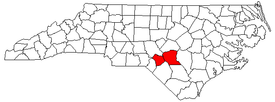
Fayetteville, North Carolina metropolitan area

The Fayetteville Metropolitan Statistical Area, as defined by the United States Census Bureau, is an area consisting of two counties – Cumberland and Hoke – in eastern North Carolina, anchored by the city of Fayetteville.Its served with only one major Interstate which is Interstate 95 As of the 2000 census, the MSA had a population of 336,609 as of the 2010 census the MSA had a population of 366,383. In 2011 the estimated population was 374,157[1]
Counties
Communities
- Places with more than 100,000 inhabitants
- Fayetteville (Principal city)
- Places with 10,000 to 30,000 inhabitants
- Places with 1,000 to 10,000 inhabitants
- Places with less than 1,000 inhabitants
- Ashley Heights
- Bowmore
- Dundarrach
- Falcon (partial)
- Five Points
- Godwin
- Linden
- Stedman
- Wade
Transportation
Demographics
As of the census[2] of 2000, there were 336,609 people, 118,731 households, and 86,364 families residing within the MSA. The racial makeup of the MSA was 54.09% White, 35.17% African American, 2.54% Native American, 1.77% Asian, 0.28% Pacific Islander, 3.14% from other races, and 3.00% from two or more races. Hispanic or Latino of any race were 6.93% of the population.
The median income for a household in the MSA was $35,348, and the median income for a family was $38,785. Males had a median income of $28,117 versus $21,782 for females. The per capita income for the MSA was $15,506.
See also
- North Carolina census statistical areas
- List of cities, towns, and villages in North Carolina
- List of unincorporated communities in North Carolina
References
- ↑ "Table 1. Annual Estimates of the Population of Metropolitan and Micropolitan Statistical Areas: April 1, 2000 to July 1, 2009 (CBSA-EST2009-01)". 2009 Population Estimates. United States Census Bureau, Population Division. 2010-03-23. Archived from the original (CSV) on June 15, 2010. Retrieved 2010-03-24.
- ↑ "American FactFinder". United States Census Bureau. Retrieved 2008-01-31.