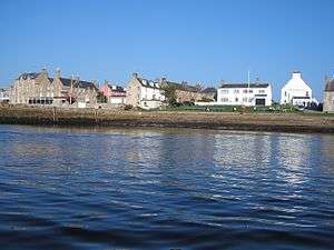
Findhorn
Findhorn (Scottish Gaelic: Inbhir Èir or Inbhir Èireann)[1] is a village in Moray, Scotland. It is located on the eastern shore of Findhorn Bay and immediately south of the Moray Firth. Findhorn is 3 miles (5 km) northwest of Kinloss, and about 5 miles (9 km) by road from Forres.
The Findhorn Foundation, an educational charity with its associated ecovillage, is located to the south of the village.
History

Original settlement
The existing settlement is the second village to bear this name, the original having been a mile to the northwest of the present position and inundated by the sea. This transposition was not an overnight catastrophe but a gradual withdrawal from the earlier site during the late seventeenth and early eighteenth centuries. Some sources (e.g. Graham), claim it is the third village to bear the name, perhaps erroneously assuming that the seventeenth century destruction of the nearby Barony of Culbin by shifting sands resulted in an earlier relocation.
Although surely Gaelic in origin the derivation of the name of the River Findhorn is not absolutely clear. Its contemporary Gaelic name is Uisge Fionn Èireann, but ti has been suggested that Fionn Èireann may be a corruption of Fionn-Dearn, "the white river Dearn". There is also the possibility that Findhorn is Gaelic Fionn-dearna "white palm [of the hand]" or Fionn-dorn "white fist" or "white hilt".
Major seaport
In the seventeenth century Findhorn was the principal seaport of Moray and vessels regularly sailed to and from all parts of the North Sea and as far as the Baltic Ports. Changes to the narrow and shallow entrance to the Bay created obstacles to navigation and as the size of trading vessels increased so the volume of trade to the village declined.
Findhorn Bay witnessed a brief episode in the 1745 Jacobite Rebellion. In March 1746 the French brigantine Le Bien Trouvé entered the tidal waters with dispatches for Bonnie Prince Charlie but her departure, with the Prince’s aide-de-camp on board, was delayed by the arrival of two British men-o’-war. Unable to enter the shallow bay, the two warships lay in wait in the Firth. Somehow Le Bien Trouvé slipped out and away to safety on a dark night. The name is recalled in the modern-day training gig of the same name which is based at Findhorn.
Fishing village
During the nineteenth century fishing predominated. During the 1829 floods known as "The Muckle Spate" five Findhorn fishing boats rescued Forres residents. For a few years (1860-9) there was a branch railway line to the village to take advantage of the herring fleet.
Modern times
The early twentieth century saw a decline in fishing as the traditional two-masted zulus were in their turn being replaced by larger vessels. Some of the craft, 'temporarily' beached on the western shore of the Bay whilst their crews fought in the First World War, were never used again. The wreckage is still visible at low tide. The shore-based salmon fisheries lasted until the 1980s but they too are no more. Today the village is a dormitory suburb and leisure craft dominate the moorings.
The Crown and Anchor Inn, dating from 1739, is the oldest surviving structure in the village. Other prominent buildings of note include Findhorn House built in 1775, which is the home of the Royal Findhorn Yacht Club, The Kimberley Inn, the James Milne Institute, The Universal Hall at the Findhorn Foundation and the ice house Heritage Centre.
Findhorn Golf Club (now defunct) was founded in 1926 and continued until WW2.[2]
References
- ↑ "Gaelic Place-Names of Scotland database". Ainmean-Àite na h-Alba. Retrieved 24 March 2016.
- ↑ “Findhorn Golf Club, Moray”, “Golf’s Missing Links”.
- Graham, C. (1977). Portrait of the Moray Firth. London. Robert Hale.
- Cochrane, R.G. & Shand, W. (1981). Findhorn: A Scottish Village. Findhorn Press.
- Lauder, T.D. (1873). An Account of the Great Floods of August 1829. J. McGillivary.
- McKean, Charles (1987). The District of Moray: An Illustrated Architectural Guide. Scottish Academic Press.
- Sellar, W.D.H. (editor) (1993). Moray: Province and People. Scottish Society for Northern Studies.
- Ross, Sinclair (1992). The Culbin Sands: Fact and Fiction. University of Aberdeen.
External links
| Wikimedia Commons has media related to Findhorn. |
Coordinates: 57°39′32″N 3°36′40″W / 57.659°N 3.611°W
