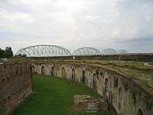
Fort Pike Bridge
| Fort Pike Bridge | |
|---|---|
|
Bridge seen from Fort Pike, 2010 | |
| Coordinates | 30°10′20″N 89°50′40″W / 30.17222°N 89.84444°W |
| Carries |
2 lanes of |
| Crosses | Rigolets |
| Locale | New Orleans and Slidell (Louisiana) |
| Other name(s) | Rigolets Bridge |
| Characteristics | |
| Design | Through truss swing bridge (old), box girder bridge (new) |
| Total length | 3,877.9 feet (1,182 m) |
| Width | 20 feet (6 m) (old), 40 feet (12 m) |
| Longest span | 399.8 feet (122 m) |
| Clearance below | 14.9 feet (5 m)(old), 72 feet (22 m) (new) |
| History | |
| Opened |
June 9, 1930 (old) January 15, 2008 (new) |
The Fort Pike Bridge (also known as the Rigolets Bridge) carries U.S. Route 90 across the Rigolets on the eastern side of Lake Pontchartrain between New Orleans and Slidell in Louisiana.[1] The bridge opened on June 9, 1930, and along with the Chef Menteur Bridge provided a free route between New Orleans and the Mississippi Gulf Coast. A new span was constructed just to the north of the old span.

High-rise replacement
Construction of a new $50 million high-rise bridge began in October 2004. It was delayed by Hurricane Katrina in 2005, which pushed a devastating storm surge through the area. The new bridge is just over one mile (1.6 km) in length and features two 12-foot (3.7 m) lanes with 8-foot (2.4 m) shoulders on both sides. The bridge rises to 72 feet (22 m) to allow marine traffic to pass without interruption of bridge traffic. The new span opened to traffic on January 15, 2008. After completion, of the new span, the old bridge was demolished.[2]
See also
-
 Bridges portal
 -
 Louisiana portal
 -
 New Orleans portal
References
- ↑ "Fort Pike/Rigolets Bridge". bridgehunter.com. Retrieved 2015-07-09.
- ↑ Rhoden, Robert (January 15, 2008). "New highrise Rigolets bridge opens". The Times Picayune. Retrieved 2008-05-04.