Georgia State Route 103
| ||||
|---|---|---|---|---|
|
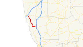
Georgia State Route 103 highlighted in red | ||||
| Route information | ||||
| Maintained by GDOT | ||||
| Length: | 13.9 mi[1] (22.4 km) | |||
| Major junctions | ||||
| South end: |
| |||
| North end: |
| |||
| Location | ||||
| Counties: | Harris, Troup | |||
| Highway system | ||||
| ||||
State Route 103 (SR 103) is a 13.9-mile-long (22.4 km) state highway in the west-central part of the U.S. state of Georgia. The highway travels from a point northwest of Mulberry Grove northwest to West Point.
Route description
SR 103 begins at an intersection with SR 219 northwest of Mulberry Grove, in Harris County. Past this intersection, the roadway continues as SR 116. SR 103 travels to the west-southwest, and then curves to the north. Just before an intersection with the southern terminus of Pine Lake Road, it begins to curve to the northwest. The highway continues to the north-northwest and enters Troup County and the city limits of West Point, where it meets its northern terminus, an intersection with SR 18.[1]
SR 103 is not part of the National Highway System, a system of roadways important to the nation's economy, defense, and mobility.[2]
Major intersections
| County | Location | mi[1] | km | Destinations | Notes |
|---|---|---|---|---|---|
| Harris | | 0.0 | 0.0 | Southern terminus of SR 103; western terminus of SR 116 | |
| Troup | West Point | 13.9 | 22.4 | Northern terminus | |
| 1.000 mi = 1.609 km; 1.000 km = 0.621 mi | |||||
See also
-
.svg.png) Georgia (U.S. state) portal
Georgia (U.S. state) portal -
 U.S. Roads portal
References
- 1 2 3 Google (October 20, 2012). "Route of SR 103" (Map). Google Maps. Google. Retrieved October 20, 2012.
- ↑ National Highway System: (Draft) Georgia (PDF) (Map). Federal Highway Administration. November 15, 2013. Retrieved May 14, 2014.

