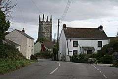
Gorran Churchtown
| Gorran Churchtown | |
 Gorran Churchtown with tower of St Goran's church in the background |
|
 Gorran Churchtown |
|
| OS grid reference | SW998422 |
|---|---|
| Civil parish | St Goran |
| Unitary authority | Cornwall |
| Ceremonial county | Cornwall |
| Region | South West |
| Country | England |
| Sovereign state | United Kingdom |
| EU Parliament | South West England |
Coordinates: 50°14′46″N 4°48′32″W / 50.246°N 4.809°W
Gorran Churchtown is a village in the parish of St Goran, Cornwall, England.[1] Gorran Churchtown is situated approximately nine miles (14 km) south-southwest of St Austell; Gorran Haven, the largest settlement in the parish, is a mile to the east.[1]
Gorran Churchtown lies within the Cornwall Area of Outstanding Natural Beauty (AONB). Almost a third of Cornwall has AONB designation, with the same status and protection as a National Park.
References
External links
| Wikimedia Commons has media related to Gorran Churchtown. |
This article is issued from Wikipedia - version of the 1/20/2016. The text is available under the Creative Commons Attribution/Share Alike but additional terms may apply for the media files.