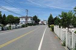
Green Harbor, Massachusetts
| Green Harbor, Massachusetts | |
|---|---|
| Census-designated place | |
|
Bay Avenue | |
| Nickname(s): Green Harbor | |
| Motto: I Love Green Habah | |
| Coordinates: 42°4′25″N 70°39′22″W / 42.07361°N 70.65611°WCoordinates: 42°4′25″N 70°39′22″W / 42.07361°N 70.65611°W | |
| Country | United States |
| State | Massachusetts |
| County | Plymouth |
| Area | |
| • Total | 1.9 sq mi (5.0 km2) |
| • Land | 1.8 sq mi (4.6 km2) |
| • Water | 0.2 sq mi (0.4 km2) |
| Population (2010) | |
| • Total | 2,609 |
| • Density | 1,400/sq mi (520/km2) |
| Time zone | Eastern (EST) (UTC-5) |
| • Summer (DST) | EDT (UTC-4) |
| Area code(s) | 339 / 781 |
| FIPS code | 25-27147 |
Green Harbor-Cedar Crest is a census-designated place (CDP) in the towns of Duxbury, Massachusetts and Marshfield, Massachusetts in Plymouth County, United States. It includes the village of Green Harbor. Cedar Crest is the name of a hill located on the north side of Careswell St. The population was 2,609 at the 2010 census.[1]
History
Green Harbor was originally known as "Green's Harbor." The name derives from William Green. The Pilgrim government granted William Green rights to conduct commercial fishing there in about 1627. The original name for Cedar Crest was Gotham Hill. In the 1920s 3 seasonal children's camps were created on the west end of the hill. The Immaculate Conception Boys Brigade, under the direction of Monsignor Edward M. Hartigan from the Immaculate Conception Church in Everett, MA, bought out the other 2 camps and created 1 camp. At the time the hill did not have any trees since it had been farmland for a number of years. There was a growth of small cedar trees on the top of the hill. This inspired Monsignor Hartigan to name the combined camps "Cedar Crest" and the name was emblazoned on the side of the hill in white painted stones. Ever since, the entire hill has been called Cedar Crest.
Geography
Green Harbor-Cedar Crest is located at 42°4′25″N 70°39′22″W / 42.07361°N 70.65611°W (42.073624, -70.656161).[2]
According to the United States Census Bureau, the CDP has a total area of 5.0 km² (1.9 mi²), of which 4.6 km² (1.8 mi²) is land and 0.4 km² (0.2 mi²) (8.29%) is water.
Demographics
As of the census[3] of 2000, there were 2,397 people, 869 households, and 662 families residing in the CDP. The population density was 519.9/km² (1,349.3/mi²). There were 1,117 housing units at an average density of 242.3/km² (628.8/mi²). The racial makeup of the CDP was 98.50% White, 0.38% African American, 0.08% Native American, 0.21% Asian, 0.04% Pacific Islander, 0.54% from other races, and 0.25% from two or more races. Hispanic or Latino of any race were 1.21% of the population.
There were 869 households out of which 37.5% had children under the age of 18 living with them, 62.0% were married couples living together, 10.5% had a female householder with no husband present, and 23.8% were non-families. 18.4% of all households were made up of individuals and 5.6% had someone living alone who was 65 years of age or older. The average household size was 2.76 and the average family size was 3.18.
In the CDP the population was spread out with 27.0% under the age of 18, 5.7% from 18 to 24, 31.6% from 25 to 44, 26.5% from 45 to 64, and 9.2% who were 65 years of age or older. The median age was 38 years. For every 100 females there were 92.8 males. For every 100 females age 18 and over, there were 89.4 males.
The median income for a household in the CDP was $74,375, and the median income for a family was $81,275. Males had a median income of $43,750 versus $38,913 for females. The per capita income for the CDP was $29,200. About 1.8% of families and 2.6% of the population were below the poverty line, including 2.4% of those under age 18 and none of those age 65 or over.
References
- ↑ "Profile of General Population and Housing Characteristics: 2010 Demographic Profile Data (DP-1): Green Harbor-Cedar Crest CDP, Massachusetts". U.S. Census Bureau, American Factfinder. Retrieved March 22, 2012.
- ↑ "US Gazetteer files: 2010, 2000, and 1990". United States Census Bureau. 2011-02-12. Retrieved 2011-04-23.
- ↑ "American FactFinder". United States Census Bureau. Retrieved 2008-01-31.
4. Stephen G. De Castro

