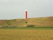
Groote Kaap
 Groote Kaap Lighthouse | |
 Netherlands | |
| Location |
Den Helder Netherlands |
|---|---|
| Coordinates | 52°52′51.3″N 4°42′53.2″E / 52.880917°N 4.714778°ECoordinates: 52°52′51.3″N 4°42′53.2″E / 52.880917°N 4.714778°E |
| Year first constructed |
1871 (first) 1966 (second) |
| Year first lit | 1985 (current) |
| Construction | steel tower |
| Tower shape | cylindrical tower with balcony and lantern |
| Markings / pattern | red tower and white lantern |
| Height | 16.8 metres (55 ft) |
| Focal height | 31 metres (102 ft) |
| Range |
white: 11 nautical miles (20 km; 13 mi) red and green: 8 nautical miles (15 km; 9.2 mi) |
| Characteristic | Oc WRG 10s. |
| Admiralty number | B0849 |
| NGA number | 9876 |
| ARLHS number | NET-077[1] |
| Netherlands number | 1482[2] |
Groote Kaap (Great Cape) (also known as the Julianadorp Lighthouse) is a round steel lighthouse painted red with a white light casing on the North Sea coast in the dunes near Julianadorp by the sea, in the municipality of Den Helder. The construction of the tower was completed in 1966. The tower was replaced in 1985.
The tower is 16.8 metres high, and the light has a height of 31 metres above sea level. It is listed with the international number of B0849 and national number of 1482.
Light
- Visibility in nautical miles: white 11; red and green, 8
- Light Character: Oc WRG 10s
- Light source: Halogen, 24V 250W
See also
References
- ↑ "Zanddijk (Large Tower)/ Groote Kaap Light - ARLHS NET-077". World List of Lights (WLOL). Amateur Radio Lighthouse Society. Retrieved 30 July 2011.
- ↑ Lighthouses Directory
External links
This article is issued from Wikipedia - version of the 2/21/2016. The text is available under the Creative Commons Attribution/Share Alike but additional terms may apply for the media files.