Gulf of Khambhat
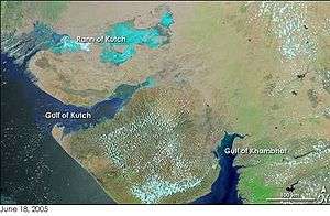
Gulf of Khambhat on the right. Image NASA Earth Observatory
_1896.jpg)
Gulf of Cambay (North part) 1896
_1896.jpg)
Gulf of Cambay (South part) 1896
The Gulf of Khambhat (also known as the Gulf of Cambay)[1] is an inlet of the Arabian Sea along the west coast of India, in the state of Gujarat. It is about 130 kilometres (80 mi) miles in length,[1] and divides the Kathiawar peninsula to the west from the eastern part of Gujarat state.
The Narmada, Tapti, Mahi and Sabarmati rivers drain into it.
There are plans to construct a 30-kilometre (19 mi) dam across the gulf.[2]
See also
References
- 1 2
 Chisholm, Hugh, ed. (1911). "Cambay, Gulf of". Encyclopædia Britannica (11th ed.). Cambridge University Press.
 - ↑ "The Gulf of Khambhat Development Project". Gujarat. Retrieved 18 May 2013.
Coordinates: 21°30′N 72°30′E / 21.500°N 72.500°E
This article is issued from Wikipedia - version of the 11/28/2016. The text is available under the Creative Commons Attribution/Share Alike but additional terms may apply for the media files.