Harrison Point Lighthouse
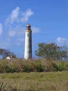 Harrison Point Lighthouse in 2008 | |
 Harrison Point Lighthouse Barbados | |
| Location |
Saint Lucy Barbados |
|---|---|
| Coordinates | 13°18′30.7″N 59°38′53.4″W / 13.308528°N 59.648167°WCoordinates: 13°18′30.7″N 59°38′53.4″W / 13.308528°N 59.648167°W |
| Year first constructed | 1925 |
| Deactivated | 2007-2011 |
| Construction | concrete block |
| Tower shape | cylindrical tower with balcony and lantern |
| Markings / pattern | white tower and red lantern |
| Height | 26 metres (85 ft) |
| Focal height | 59 metres (194 ft) |
| Range | 3 nautical miles (5.6 km; 3.5 mi) |
| Characteristic | F R |
| Admiralty number | J5814 |
| NGA number | 15128 |
| ARLHS number | BAR-001[1] |
Harrison Point Lighthouse is a lighthouse located in the northern Parish of Saint Lucy, Barbados.
History
The lighthouse has a cylindrical shape and it was the latest, of four lighthouses, to be built on the island, in 1925. It is built in concrete block, it has an height of 26 metres (85 ft) and a focal height of 59 metres (194 ft). The tower is white painted and the lantern is red; its characteristic, before the temporary deactivation. was two white flashes every 15 seconds.[2] The lighthouse was deactivated probably in 2007, as reported by Admiralty, because it was on the ground of a prison; the tower was abandoned and the keeper’s house ruined. In 2011 the Admiralty confirmed the activity of the lighthouse with a continuous red light.
See also
References
- ↑ Harrison Point The Lighthouse Directory. University of North Carolina at Chapel Hill. Retrieved 7 August 2016
- ↑ Barbados.org
| Wikimedia Commons has media related to Harrison Point Lighthouse. |
This article is issued from Wikipedia - version of the 8/7/2016. The text is available under the Creative Commons Attribution/Share Alike but additional terms may apply for the media files.