Heimgarten (mountain)
| Heimgarten | |
|---|---|
|
Heimgarten | |
| Highest point | |
| Elevation | 1,790 m (5,870 ft) |
| Prominence | 889 m (2,917 ft) [1] |
| Coordinates | 47°36′49.2″N 11°16′27.6″E / 47.613667°N 11.274333°ECoordinates: 47°36′49.2″N 11°16′27.6″E / 47.613667°N 11.274333°E |
| Geography | |
 Heimgarten Location of Heimgarten in Germany | |
| Location | Bavaria, Germany |
| Parent range | Bavarian Prealps |
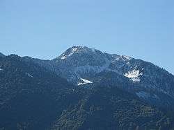
Heimgarten (elevation 1,790 metres/5,870 ft) is a mountain near Ohlstadt in the Bavarian Prealps of southern Germany. It is connected via a ridge with Herzogstand (1,731 metres/5,679 ft) to the east.[2]
References
- ↑ "Heimgarten - peakbagger". peakbagger.com. Retrieved 25 March 2015.
- ↑ BY 9: Estergebirge, Herzogstand, Wank (Map). 1:25000. Alpenvereinskarte Bayerische Alpen. Deutscher Alpenverein. 2009.
This article is issued from Wikipedia - version of the 3/25/2015. The text is available under the Creative Commons Attribution/Share Alike but additional terms may apply for the media files.