Hillary Peak
| Hillary Peak | |
|---|---|
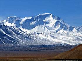
 The North Face of Cho Oyu from Tingri in Tibet. The Ngojumba Kang peaks are on the left. | |
| Highest point | |
| Elevation | 7,681 m (25,200 ft) [1] |
| Coordinates | 28°06′24″N 86°42′58″E / 28.10667°N 86.71611°ECoordinates: 28°06′24″N 86°42′58″E / 28.10667°N 86.71611°E |
| Geography | |
 Hillary Peak Location in Nepal | |
| Location | Solukhumbu, Nepal |
| Parent range | Himalayas |
Hillary Peak is the name which has been proposed by the Government of Nepal for a 7,681 metres (25,200 ft) peak in the Himalayas in honour of Edmund Hillary, who made the first ascent of Everest with Tenzing Norgay in 1953.[2]
In September 2013 a government panel recommended that two mountains be renamed Hillary Peak and Tenzing Peak as part of a batch of summits that would be opened to climbers in 2014. The coordinates given by the government indicate that it is one of a clutch of peaks on the Nepal and Tibet border between Cho Oyu and Gyachung Kang, known variously as Ngojumba Kang, Ngozumpa Kang and Ngojumba Ri.[3]
References
- ↑ "Mount Everest: Hillary and Tenzing to have peaks named after them". The Guardian. 6 September 2013.
- ↑ "Mount Everest: Hillary and Tenzing to have peaks named after them". The Guardian. 6 September 2013.
- ↑ "Government of Nepal officially opens 104 new peaks for montaineering". Retrieved 27 November 2016.
This article is issued from Wikipedia - version of the 11/27/2016. The text is available under the Creative Commons Attribution/Share Alike but additional terms may apply for the media files.