Hugh R. Thomas Bridge
| Hugh R. Thomas Bridge | |
|---|---|
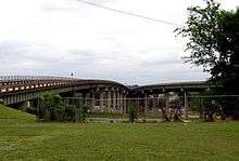
 Hugh R. Thomas Bridge as seen towards the north, between the split spans of Lurleen Wallace Blvd. | |
| Coordinates | 33°12′51.86″N 87°34′25.5″W |
| Carries |
6 lanes of |
| Crosses | Black Warrior River |
| Locale | Tuscaloosa, Alabama |
| Maintained by | Alabama Department of Transportation |
| History | |
| Opened | 1974 |
| Statistics | |
| Daily traffic | 68,370 (2008) |
The Hugh Rowe Thomas Bridge is a six-lane, girder bridge spanning the Black Warrior River along U.S. Route 43 and Alabama State Route 69 connecting downtown Tuscaloosa and Northport in Tuscaloosa County, Alabama that opened in 1974.[1] The bridge is split in Tuscaloosa to accommodate two major, one-way thoroughfares (Lurleen Wallace Boulevard North and South), before joining together heading towards Northport. It replaced a lift bridge that was built in 1922 and demolished in 1973.
As of 2008, the average daily traffic count for the bridge is approximately 68,400 vehicles.[2] This is one of only four vehicular bridges spanning the Black Warrior in Tuscaloosa.
The bridge was named in honor of Alabama State Representative Hugh Rowe Thomas who was killed in a car wreck in April 1967 while traveling to Montgomery for a special session. He had been elected in 1966 and was just 33 years old.[3] Thomas was one of three children of famed University of Alabama football coach Frank Thomas and wife Frances Rowe.[4]
See also
-
 Bridges portal
 -
 Alabama portal
 - List of crossings of the Black Warrior River
References
- ↑ Alabama Department of Archives & History. "ADAH: Tuscaloosa Historical Markers". Archived from the original on 2007-08-20. Retrieved 2008-02-07.
- ↑ ISTEA. "ISTEA Reauthorization: Member Policy Initiatives and Requests for Highway & Transit Projects in the ISTEA Reauthorization". Retrieved 2006-12-06.
- ↑ "New Bridge Named Officially Thomas". The Tuscaloosa News. Retrieved 2013-03-18.
- ↑ "Hughie Thomas' Lucky Hat". Remember the Rose Bowl. Retrieved 2013-03-18.
Coordinates: 33°12′52″N 87°34′26″W / 33.21447°N 87.57379°W