Hump Ridge Track
| Tuatapere Humpridge Track | |
|---|---|
|
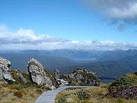
Boardwalk on the track up near Okaka hut, looking out to Lake Poteriteri | |
| Established | 2001 |
| Length | 56.5 km (35.1 mi) |
| Location | Fiordland National Park, New Zealand |
| Trailheads | Rarakau Carpark |
| Use | Tramping |
| Elevation | |
| Highest point | Loop track above Okaka Lodge 978 m (3,209 ft) |
| Lowest point | Sea level, 4 m (13 ft) |
| Hiking details | |
| Trail difficulty | hard/medium |
| Season | Summer to autumn |
| Months | October to April. Can be walked in winter months too, but Tuatapere Office is closed |
| Sights | Viaducts, alpine views, beaches, forests, tussocklands, Foveaux Strait, historic relics |
| Hazards | Tree roots, hypothermia, sunburn, high winds, rocks, snow & rain |
| Surface | dirt, rock, sand, tree roots, railway sleepers, boardwalk |
| Website | Tuatapere Hump Ridge Track website |
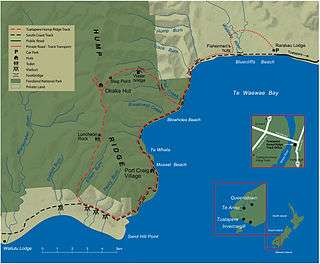
The Hump Ridge Track (sometimes called the Tuatapere Humpridge Track) is located in the south east of Fiordland National Park, in the South Island of New Zealand. The track is about 56.5 km in distance and is based in Waitutu Forest (part of Fiordland National Park).
About 1800 walkers complete the track each year.[1] The closest town is Tuatapere, although people often stay in Te Anau and opt to drive south the morning of beginning the track. The track was established in November 2001, with the initial cost for the project at $3,950,000 NZD.[2] The track crosses Māori land and much privately owned land. The Tuatapere Hump Track Trust owns two lodges and over 20 km of board walk, although the Department of Conservation maintains the track along the coast and the Port Craig School Hut.

Route
The track starts from Bluecliffs Beach at the Rarakau Farm car park. Usually the track is walked in an anti-clockwise direction, meaning the first night is spent at Okaka Lodge which is over 900 metres up on the hump ridge itself. From this vantage point there are panoramic views of Fiordland and the sea to the south, including Stewart Island and neighbouring smaller islands. The track crosses three large viaducts (including the impressive Percy Burn Viaduct), with a fourth visible from the track but off-limits to walkers. The second night's stay is at the coastal Port Craig Village, with beautiful Mussel beach within easy strolling distance. The third day's journey returns to the start of the loop through native bush, then back along Blowholes Beaches and Bluecliffs Beach before finally arriving back at the car park.
Between six and nine hours walking is required each day to complete the track. The first day includes a 900-metre ascent to the top of the ridge. The second day is mostly downhill, but can still be rather long towards the end.
Distance
Most sources put the track between 55 and 63 km but several GPS tracked devices have measured it at 56.5 km (as of 2014). The exact length of the track is unknown because of several factors such as the method of measurement and path taken. At several points there is the option to walk via the beach, the track or a four-wheel drive track which can alter the distance. The distance may change because of the complex path up and down the mountain through trees and over roots which will vary depending on the walker. Mapping the distance on a map also does not give its true length as there are many changes in elevation. There are several side routes such as the loop track above Okaka Lodge and the beach at Port Craig which will add to the distance travelled. There is also an additional 300 metres from the car park to the start of the track.
Surface and terrain
Most of the coastal track is flat and the surface is made of sand or dirt and is easy to walk on. However it can get very boggy near the viaducts between Port Craig and Edwin Burn; this area also has many hundreds of railway sleepers left over from the logging. The hill sections are very delicate and much of it has been laid with boardwalk making walking easier and protecting the ecosystem. Sections that are not covered with boardwalk can have many trees, roots, and much mud to contend with.
Stump the Hump
The Stump the Hump is an annual walking event that traverses the Hump Ridge track in the standard anti-clockwise direction. It was started in 2011 and walkers start early at midnight on a Friday in February with lights to guide their way. It is expected most walkers will finish the track in less than 24 hours. Any money raised goes to track maintenance.[3]
Flora and fauna
Near the coast are dense forests of rimu, miro, Hall's tōtara and rātā. The lower terraces are mainly podocarp and silver beech, while the higher terraces are dominated by yellow-silver pine. Birds that can be seen include the kaka, kea, yellow-crowned parakeet, South Island robin, fantail, bellbird, grey warbler and South Island tomtit. Hector's dolphins are often seen around Port Craig and occasionally people are able to swim with them.[4]
History
The track crosses three big viaducts — the largest, the Percy Burn is thought to be one of the biggest wooden viaducts in the Southern Hemisphere and is referenced in Warren Bird's book Viaducts Against the Sky.
The Waitutu area was visited by early Māori in search of food from the sea, rivers and forests. Kaika or hunting camps were sited on the banks of the Waiau River, near Tuatapere, and the river crossed by mokihi or rafts. Tracks led along the terraces and beaches, probably very close to the track of today, providing access to Sandhill Point, the Wairaurahiri River, and beyond.
The coastal track was first cut by government workers in 1896 to provide an alternative to the unreliable shipping service to Cromarty and Te Oneroa, gold mining settlements of Preservation Inlet.
In 1908 a telephone line was installed along the track linking the Puysegur Point Lighthouse with Orepuki. Insulators, wire and old maintenance workers' huts can still be found today.
During the 1920s Port Craig was the site of the largest and most modern sawmill in New Zealand. The Marlborough Timber Company mill employed over 200 men and produced up to 1800 cubic metres of timber a month. Port Craig is immersed in history; the current DOC hut there is the old schoolhouse that was used in the logging days.
Logs were brought to the mill along a high class tramway from the terrace forests to the west, between Port Craig and the Wairaurahiri River. Large viaducts were constructed from Australian hardwood to carry the tramlines over ravines. The largest, the Percy Burn Viaduct, is 125 metres long and 36 metres above the creek bed. It was fully repaired in 1994. The other viaducts were refurbished in 1999.
By the time milling ceased in 1929, about 14 square kilometres of forest had been logged, the timber being shipped directly from Port Craig. Old wharf piles remain, along with old building materials and the Port Craig school, which has been converted into a hut for trampers.
External links
References
- ↑ Somerville, Philip. "Stumping the Hump". odt.co.nz. Allied Press Limited. Retrieved 13 November 2014.
- ↑ "Southland's Hump Ridge Track To Be Great Walk". scoop.co.nz. Retrieved 10 November 2014.
- ↑ Whyte, Shirley. "Stump the Hump draws in the visitors". stuff.co.nz. Fairfax New Zealand LimitedS. Retrieved 13 November 2014.
- ↑ "Hump Ridge Track". doc.govt.nz. Department of Conservation. Retrieved 14 November 2014.
Coordinates: 46°08′55″S 167°28′28″E / 46.148617°S 167.474457°E
