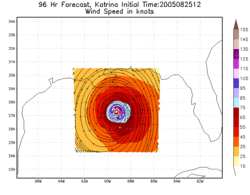
Hurricane Weather Research and Forecasting model

The Hurricane Weather Research and Forecasting (HWRF) model is a specialized version of the Weather Research and Forecasting (WRF) model and is used to forecast the track and intensity of tropical cyclones. The model was developed by the National Oceanic and Atmospheric Administration (NOAA), the U.S. Naval Research Laboratory, the University of Rhode Island, and Florida State University.[1] It became operational in 2007. [2]
About the HWRF Model
The HWRF is a new computer model that will be the operational backbone for hurricane track and intensity forecasts by the National Hurricane Center (NHC).[2] The model will use data from satellite observations, buoys, and reconnaissance aircraft, making it able to access more meteorological data than any other hurricane model before it.[2] The model will eventually run at an even higher resolution which will allow smaller scale features to become more discernible.[2]
The following model description can be found in the Product Description Document for the National Centers for Environmental Prediction's Model Analyses & Forecasts:[3]
|
Mary Glackin, acting director of NOAA’s National Weather Service, says that "It is vital that we understand all the factors of hurricane forecasting throughout the life of a storm and HWRF will provide an unprecedented level of detail. Over the next several years, this model promises to improve forecasts for tropical cyclone intensity, wave and storm surge, and hurricane-related inland flooding." She also says that the HWRF "will be one of the most dynamic tools available" for forecasters.[2]
Development of the HWRF model began in 2002.[4] In 2007, the HWRF model became operational. While the HWRF model will eventually replace the GFDL model, the GFDL model will continue to be run in 2007.[5] The GFDL model has continued to be run operationally through 2012.
See also
- Tropical cyclone
- Tropical cyclone forecasting
- Tropical cyclone forecast model
- Tropical cyclone rainfall forecasting
- Weather forecasting
References
- ↑ "Weather Forecast Accuracy Gets Boost with New Computer Model". UCAR press release. Retrieved 2007-07-09.
- 1 2 3 4 5 "New Advanced Hurricane Model Aids NOAA Forecasters". NOAA Magazine. Retrieved 2007-07-09.
- ↑ "Product Description Document: NCEP Model Analyses & Forecasts" (PDF). NCEP. Retrieved 2007-07-11.
- ↑ "NCEP Numerical Modeling: Where We Are and Where We're Going" (Large PowerPoint file). NCEP. January 11, 2007. Retrieved 2007-07-15.
- ↑ Pasch, Richard. "The Hurricane Weather Research and Forecasting (HWRF) Model" (Large PowerPoint file). Retrieved 2007-07-15.
Websites with the HWRF model
- Community Code from DTC
- Model Analyses and Forecasts from NCEP
- Experimental forecast Tropical Cyclone Genesis Potential Fields from Florida State University
- Cyclone phase evolution: Analyses & Forecasts from Florida State University
- Tropical Cyclone Tracking Page - Model track performance from Kinetic Analysis Corporation and University of Central Florida