Ikungi District
| Ikungi District | |
|---|---|
| District | |
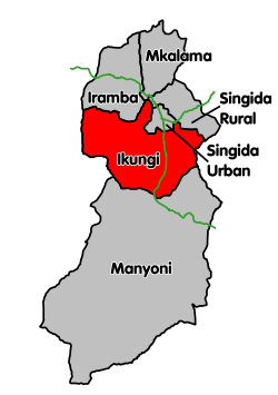
 Ikungi District's location within Singida Region. | |
| Coordinates: 05°08′S 34°46′E / 5.133°S 34.767°ECoordinates: 05°08′S 34°46′E / 5.133°S 34.767°E | |
| Country | Tanzania |
| Region | Singida Region |
| Population (2012) | |
| • Total | 272,959 |
Ikungi District is one of the six districts of the Singida Region of Tanzania. It is one of the 20 new districts that were formed in Tanzania since 2010; it was split off from Singida Rural District.[1] Ikungi District is bordered to the north by Iramba District, Singida Urban District and Singida Rural District, to the east by Manyara Region, to the south by Manyoni District and to the west by Tabora Region. Its administrative seat is the town of Ikungi.
According to the 2012 Tanzania National Census, the population of Ikungi District was 272,959.[2]
Transport
Paved trunk road T3 from Morogoro to the Rwandan border passes through the district.[3]
The Singida branch of the Central Railway of Tanzanian Railways passes through the district. There is a station at Ikungi town.
Administrative subdivisions
As of 2012, Ikungi District was administratively divided into 26 wards.[2]
Wards 2012
| Ward | Population | Population - Male | Population - Female | Number of Households | Average Household Size |
|---|---|---|---|---|---|
| Puma | 9,945 | 4,795 | 5,150 | 1,999 | 5 |
| Kituntu | 8,444 | 4,219 | 4,225 | 1,497 | 5.6 |
| Mungaa | 18,276 | 8,903 | 9,373 | 3,554 | 5.1 |
| Siuyu | 7,952 | 3,987 | 3,965 | 1,472 | 5.4 |
| Kikio | 7,887 | 3,937 | 3,950 | 1,515 | 5.2 |
| Lighwa | 7,245 | 3,575 | 3,670 | 1,349 | 5.4 |
| Misughaa | 6,679 | 3,376 | 3,303 | 1,302 | 5.1 |
| Ntuntu | 11,360 | 5,738 | 5,622 | 2,124 | 5.3 |
| Dung'unyi | 10,158 | 5,111 | 5,047 | 1,994 | 5.1 |
| Mang'onyi | 14,962 | 7,903 | 7,059 | 3,053 | 4.9 |
| Mkiwa | 5,152 | 2,625 | 2,527 | 942 | 5.5 |
| Issuna | 12,158 | 6,212 | 5,946 | 2,195 | 5.5 |
| Unyahati | 9,710 | 4,870 | 4,840 | 1,956 | 5 |
| Ikungi | 12,661 | 6,331 | 6,330 | 2,533 | 5 |
| Iglansoni | 11,256 | 5,432 | 5,824 | 1,595 | 7.1 |
| Iseke | 6,933 | 3,444 | 3,489 | 1,346 | 5.2 |
| Ihanja | 8,269 | 4,169 | 4,100 | 1,620 | 5.1 |
| Minyughe | 18,440 | 9,239 | 9,201 | 4,965 | 3.7 |
| Muhintiri | 8,896 | 4,420 | 4,476 | 1,486 | 6 |
| Iyumbu | 9,377 | 4,590 | 4,787 | 1,133 | 8.3 |
| Mgungira | 6,548 | 3,198 | 3,350 | 913 | 7.2 |
| Mwaru | 11,784 | 5,752 | 6,032 | 1,929 | 6.1 |
| Ighombwe | 13,344 | 6,692 | 6,652 | 1,839 | 7.3 |
| Mtunduru | 17,056 | 8,589 | 8,467 | 2,940 | 5.8 |
| Sepuka | 12,446 | 6,092 | 6,354 | 2,352 | 5.3 |
| Irisya | 6,021 | 2,979 | 3,042 | 1,097 | 5.5 |
Wards 2002
The Singida Rural District was administratively divided into 30 wards:
- Dungunyi
- Kinyeto
- Iambi
- Ihanja
- Ikhanoda
- Ikungi
- Ilongero
- Irisya
- Issuna
- Maghojoa
- Makuro
- Mangonyi
- Matumbo
- Merya
- Mgori
- Mgungira
- Minyughe
- Misughaa
- Msisi
- Mtinko
- Mudida
- Muhintiri
- Mungaa
- Mwaru
- Ngimu
- Ntuntu
- Puma
- Sepuka
- Siuyu
- Ughandi
References
- ↑ "New constituencies up for grabs as CUF cries foul". The Citizen. Retrieved 17 February 2016.
- 1 2 "Census 2012". National Bureau of Statistics. Retrieved 16 February 2016.
- ↑ "Singida Roads Network" (PDF). Tanroads. Retrieved 11 March 2016.