Iowa Highway 91
| ||||
|---|---|---|---|---|
 | ||||
| Route information | ||||
| Length: | 4.643 mi[1] (7.472 km) | |||
| Existed: | 1980 – 2003 | |||
| Major junctions | ||||
| South end: |
| |||
| North end: |
| |||
| Location | ||||
| Counties: | Lyon | |||
| Highway system | ||||
| ||||
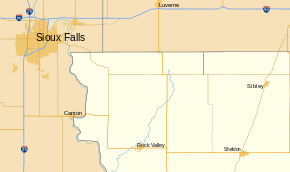
Iowa Highway 91 (Iowa 91) was a short state highway in northwestern Iowa. It began at Iowa 9 between Rock Rapids and Little Rock and ended at the Minnesota state line. It continued north as Minnesota State Highway 91. The highway was part of the primary highway system for 23 years; it was designated in 1980 and removed in 2003. After it was turned over, it became County Road L14.
Route description
Iowa 91 began in rural Lyon County at an intersection with Iowa 9 at a point nearly equidistant to Rock Rapids in the west, Little Rock east, and George south. It headed north over flat terrain with farmland on both sides of the highway.[2] Near the midpoint of the route, it crossed a branch of Tom Creek, which itself is a branch of the Rock River. The highway ended at the Minnesota state line south of Ellsworth. It continued north as Minnesota State Highway 91.[3]
History
Iowa 91 was designated in late 1980 when the Iowa Department of Transportation took over control of County Road K64 (CR K64) in Lyon County; however, it did not show up on the state map until the 1983 edition.[4][5] The route was paved when it was added to the primary highway system.[5] In 2002, more than 700 miles (1,100 km) of low-traffic state highways, including Iowa 91, were identified by the Iowa DOT because they primarily served local traffic. Typically, when the DOT wished to transfer a road to a county or locality, both parties had to agree to terms and the DOT would have to either improve the road or give money to the other party to maintain the road.[6] However, with the significant mileage the DOT wished to turn over, the Iowa General Assembly passed a law which granted the DOT a one-time exemption from the transfer rules effective July 1, 2003.[7] Iowa 91 was replaced by CR L14.[8]
Major intersections
The entire route was in Midland Township, Lyon County.
| mi[1] | km | Destinations | Notes | ||
|---|---|---|---|---|---|
| 0.000 | 0.000 | ||||
| 4.643 | 7.472 | ||||
| 1.000 mi = 1.609 km; 1.000 km = 0.621 mi | |||||
References
- 1 2 "2002 Volume of Traffic on the Primary Road System of Iowa" (PDF). Iowa Department of Transportation. January 1, 2002. Retrieved June 17, 2014.
- ↑ Topography map (Map). Cartography by United States Geological Survey. Iowa Geographic Map Server. 1976. Retrieved June 17, 2014.
- ↑ Google (June 17, 2014). "Iowa Highway 91" (Map). Google Maps. Google. Retrieved June 17, 2014.
- ↑ Iowa Department of Transportation (1980). Iowa State Highway Map (PDF) (Map). Ames: Iowa Department of Transportation. Retrieved June 17, 2014.
- 1 2 Iowa Department of Transportation (1983). Iowa State Highway Map (PDF) (Map). Ames: Iowa Department of Transportation. Retrieved June 17, 2014.
- ↑ Reeder, Greg; Stevens, Larry; Fichtner, Royce; Stoner, Tom; Wandro, Mark; Volmer, Neil (April 1, 2003). "Evaluation of the State Highway System and Road Use Tax Fund" (PDF). State of Iowa. Retrieved June 17, 2014.
- ↑ "Senate File 451". Iowa General Assembly. Retrieved June 17, 2014.
- ↑ Iowa Department of Transportation (2004). Iowa State Highway Map (PDF) (Map). Ames: Iowa Department of Transportation. Retrieved June 13, 2014.
External links
- End of Iowa 91 at Iowa Highway Ends
