Jatun Lluqhi
| Jatun Lluqhi | |
|---|---|
 Jatun Lluqhi Location within Bolivia | |
| Highest point | |
| Elevation | 2,711 m (8,894 ft) [1] |
| Coordinates | 18°31′20″S 65°35′43″W / 18.52222°S 65.59528°WCoordinates: 18°31′20″S 65°35′43″W / 18.52222°S 65.59528°W |
| Geography | |
| Location |
Bolivia, Potosí Department |
| Parent range | Andes |
Jatun Lluqhi (Quechua jatun big, lluqhi landslide,[2] "big landslide", also spelled Jatun Lluqui) is a 2,711-metre-high (8,894 ft) mountain in the Bolivian Andes. It is located in the Potosí Department, Chayanta Province, Ravelo Municipality.[1][3]
References
Capital: Potosí | ||
| Provinces | 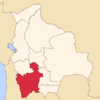 | |
| Municipalities (and seats) |
| |
This article is issued from Wikipedia - version of the 4/30/2016. The text is available under the Creative Commons Attribution/Share Alike but additional terms may apply for the media files.