John F. Kennedy Boulevard Bridge
| John F. Kennedy Boulevard Bridge | |
|---|---|
|
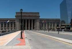
John F. Kennedy Boulevard Bridge, with 30th Street Station and the Cira Centre | |
| Coordinates | 39°57′20″N 75°10′48″W / 39.95545°N 75.18000°WCoordinates: 39°57′20″N 75°10′48″W / 39.95545°N 75.18000°W |
| Carries |
|
| Crosses | Schuylkill River, CSX Transportation tracks, Schuylkill River Trail[1] |
| Locale | Philadelphia, Pennsylvania |
| Official name | John F. Kennedy Boulevard Bridge |
| Other name(s) | JFK Boulevard Bridge, Pennsylvania Boulevard Bridge |
| Owner | Pennsylvania Department of Transportation |
| Maintained by | PennDOT |
| ID number | 670095015000000 |
| Characteristics | |
| Design | girder and floorbeam system |
| Material | steel |
| Total length | 487.9 feet |
| Width | 47.9 feet |
| Number of spans | 3 |
| Piers in water | 2 |
| History | |
| Constructed by | PennDOT |
| Construction end | 1959 |
| Opened | 1959, reconstructed 2009 |
| Statistics | |
| Daily traffic | 2,629 as of 2009 |
| BH 45857 (Bridgehunter.com ID) | |
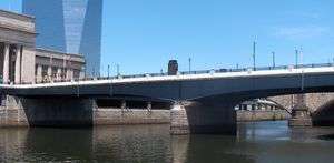
The John F. Kennedy Boulevard Bridge was built in 1959 and reconstructed 2009 by the Pennsylvania Department of Transportation. It carries three lanes (two lanes westbound, one lane eastbound) of John F. Kennedy Boulevard (known as Pennsylvania Boulevard until 1963) across the Schuylkill River, Schuylkill River Trail, and CSX Transportation tracks.[1]

John F. Kennedy Boulevard Bridge, looking west towards the 30th Street Station, with the Cira Centre on the right.
See also
List of crossings of the Schuylkill River
References
- 1 2 "JFK Boulevard Bridge, Philadelphia County, Pennsylvania". Historic Bridges of the United States. James Baughn. 2010-08-10. Retrieved 2010-08-18.
Girder bridge over Schuylkill River;CSX, on JFK Boulevard
This article is issued from Wikipedia - version of the 10/10/2016. The text is available under the Creative Commons Attribution/Share Alike but additional terms may apply for the media files.
