K-2 (Kansas highway)
| ||||
|---|---|---|---|---|
 | ||||
| Route information | ||||
| Maintained by KDOT | ||||
| Length: | 54.6 mi (87.9 km) | |||
| Major junctions | ||||
| West end: |
| |||
|
| ||||
| East end: |
| |||
| Location | ||||
| Counties: | Barber, Harper, Kingman, Sumner | |||
| Highway system | ||||
| ||||

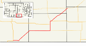
K-2 is a state highway in the south-central portion of the U.S. state of Kansas. Its southwestern terminus is at its intersection with U.S. Highway 281 east of Hardtner. Its northeastern terminus is at its intersection with K-42 west of the unincorporated town of Suppesville. It is 54.6 miles (87.9 km) long.[1]
Route description
From its western terminus in Barber County, K-2 proceeds east for 5 miles (8.0 km) to the town of Kiowa, where it forms the northern terminus of the brief southern leg of K-8. In Kiowa, K-2 turns to the north and then to the northeast, running parallel to a BNSF Railway track for about 12 miles (19 km), skirting the town of Hazelton and crossing into Harper County. K-2 then runs eastward for about 17 miles (27 km) to Anthony, where it forms the western terminus of K-44 and turns northward. Six miles north of Anthony, K-2 intersects with US-160, which it overlaps for the next four miles (6 km). Three miles north of that intersection, K-2/US-160 turn to the east, through the town of Harper. On the eastern edge of Harper, US-160 continues east, while K-2 goes north and then northeast. It continues northeast for 18 miles (29 km), clipping the southeast corner of Kingman County and crossing briefly into Sumner County, where it ends at K-42 near Suppesville.[2]
Junction list
- Margin of error: 6.8 mi
| County | Location | mi[3] | km | Destinations | Notes |
|---|---|---|---|---|---|
| Barber | | 0.0 | 0.0 | Western terminus | |
| Kiowa | 4.5 | 7.2 | Northern terminus of K-8 | ||
| Harper | Anthony | 33.6 | 54.1 | Western terminus of K-44 | |
| | 39.6 | 63.7 | Western terminus of US-160 concurrency | ||
| Harper | 42.6 | 68.6 | Southern terminus of K-14 | ||
| 43.7 | 70.3 | Eastern terminus of US-160 concurrency | |||
| Sumner | | 54.6 | 87.9 | Eastern terminus | |
1.000 mi = 1.609 km; 1.000 km = 0.621 mi
| |||||
References
- ↑ Kennedy, Richie. "Routelog". Kansas Highways 7.0. Archived from the original on 2007-09-27. Retrieved 2007-08-12.
- ↑ Official Transportation Map (PDF) (Map) (2007-08 ed.). Kansas Department of Transportation. Retrieved 2007-08-12.
- ↑ Google (2007-10-27). "K-2 (Kansas highway)" (Map). Google Maps. Google. Retrieved 2007-10-27.