Kentucky Route 10
"KY 10" redirects here. For the former congressional district, see Kentucky's 10th congressional district.
| ||||
|---|---|---|---|---|
 | ||||
| Route information | ||||
| Maintained by KYTC | ||||
| Length: | 117.760 mi[1] (189.516 km) | |||
| Major junctions | ||||
| West end: |
| |||
|
| ||||
| East end: |
| |||
| Location | ||||
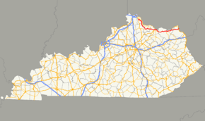
| Counties: | Campbell, Pendleton, Bracken, Mason, Lewis, Greenup | |||
| Highway system | ||||
| ||||

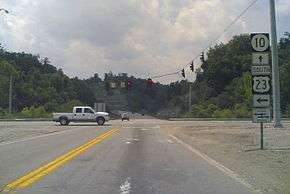
A view of the intersection of U.S. 23, KY 10, & Ohio SR 253 just after crossing the Jesse Stuart Memorial Bridge in Greenup
Kentucky Route 10, also known as KY 10, is a highway maintained by the Kentucky Transportation Cabinet that runs from Alexandria, Kentucky (a suburb of Cincinnati, Ohio) to the Jesse Stuart Memorial Bridge at Grays Branch, roughly north of Greenup, Kentucky, where the route continues into Ohio as State Route 253.
Part of its route, from Ribolt to east of Vanceburg in Lewis County, is along Kentucky Route 9. This section of KY 10, along with the section from Vanceburg to U.S. 23 just before the Jesse Stuart Memorial Bridge, is considered part of the AA Highway.
Major intersections
| County | Location | mi | km | Destinations | Notes |
|---|---|---|---|---|---|
| Campbell | | 0.000 | 0.000 | Western terminus | |
| Alexandria | 1.305 | 2.100 | |||
| 1.754 | 2.823 | Southern terminus of KY 547 | |||
| 2.055 | 3.307 | Northern terminus of KY 1121 | |||
| | 4.423 | 7.118 | Southern terminus of KY 1997 | ||
| | 5.701 | 9.175 | Western end of KY 1996 overlap | ||
| | 6.197 | 9.973 | Eastern end of KY 1996 overlap | ||
| Flagg Spring | 11.682 | 18.800 | west terminus of KY 735 | ||
| | 14.805 | 23.826 | Southern terminus of KY 1121 | ||
| Pendleton | Peach Grove | 17.578 | 28.289 | ||
| | 20.933 | 33.688 | Western end of KY 159 overlap | ||
| Mount Auburn | 21.184 | 34.092 | Eastern end of KY 159 overlap | ||
| Bracken | Lenoxburg | ||||
| | 29.070 | 46.784 | Southern terminus of KY 1109 | ||
| | 30.639 | 49.309 | Southern terminus of KY 1011 | ||
| | 31.338 | 50.434 | Eastern terminus of KY 2902 | ||
| Willow | 33.954 | 54.644 | Eastern terminus of KY 22 | ||
| Powersville | 36.606 | 58.912 | Western end of KY 19 overlap | ||
| Brooksville | 40.185 | 64.671 | Southern terminus of KY 1159 | ||
| 40.524 | 65.217 | Eastern end of KY 19 overlap | |||
| | 45.630 | 73.434 | Western end of KY 875 overlap | ||
| Germantown | 46.761 | 75.255 | Eastern end of KY 875 overlap | ||
| Mason | 46.960 | 75.575 | Western terminus of KY 596 | ||
| Fernleaf | 49.902 | 80.309 | Southern terminus of KY 435 | ||
| | 50.742 | 81.661 | Western end of KY 9 overlap | ||
| | |||||
| Maysville | interchange | ||||
| 59.459 | 95.690 | east end of KY 9 overlap; west end of US 62 / US 68 Bus. overlap | |||
| east end of US 62 / US 68 Bus. overlap | |||||
| 59.811 | 96.256 | Lexington Street (KY 2519 south) | Northern terminus of KY 2519 | ||
| 60.830 | 97.896 | east terminus of KY 2513 | |||
| | 61.816 | 99.483 | Northern terminus of KY 1449 | ||
| | 67.113 | 108.008 | north terminus of KY 3161 | ||
| Rectorville | 68.074 | 109.554 | Northern terminus of KY 1237 | ||
| | 68.844 | 110.794 | Eastern terminus of KY 1234 | ||
| Lewis | Tollesboro | 71.874 | 115.670 | Western end of KY 57 overlap | |
| 71.959 | 115.807 | Eastern end of KY 57 overlap | |||
| Ribolt | 75.662 | 121.766 | Western end of KY 9 overlap | ||
| Charters | |||||
| Clarksburg | |||||
| | |||||
| Vanceburg | |||||
| | west end of KY 1149 overlap | ||||
| | 91.870 | 147.850 | Eastern end of KY 9 / KY 1149 overlap | ||
| | 93.762 | 150.895 | east end of KY 3020 | ||
| | 97.168 | 156.377 | |||
| | 99.447 | 160.044 | |||
| | 100.274 | 161.375 | |||
| | 102.480 | 164.926 | |||
| Greenup | | 105.467 | 169.733 | ||
| | 108.470 | 174.566 | Western end of KY 784 overlap | ||
| Letitia | 108.791 | 175.082 | Eastern end of KY 784 overlap | ||
| | 113.205 | 182.186 | |||
| | 116.498 | 187.485 | |||
| Grays Branch | 116.796 | 187.965 | |||
| Greenup Locks and Dam | 117.760 | 189.516 | Ohio state line (Jesse Stuart Memorial Bridge over Ohio River) | ||
1.000 mi = 1.609 km; 1.000 km = 0.621 mi
| |||||
References
- ↑ Division of Planning. "Official Milepoint Route Log Extract". Highway Information System. Kentucky Transportation Cabinet. Retrieved July 7, 2013.
External links
This article is issued from Wikipedia - version of the 3/28/2016. The text is available under the Creative Commons Attribution/Share Alike but additional terms may apply for the media files.