Kaohsiung Arena Station
Kaohsiung Arena 巨蛋 | |
|---|---|
 Kaohsiung Arena Station Exit | |
| Other names | Sanmin Household & Commercial High School; 三民家商 |
| Location |
Zuoying, Kaohsiung Taiwan |
| Operated by | |
| Line(s) |
|
| Platforms | One island platform |
| Construction | |
| Structure type | Underground |
| History | |
| Opened | March 9, 2008 |
| Traffic | |
| Passengers | 21,430 daily (Jan. 2011)[1] |
| Kaohsiung Arena Station | |||||||||||||
| Traditional Chinese | 巨蛋車站 | ||||||||||||
|---|---|---|---|---|---|---|---|---|---|---|---|---|---|
| Simplified Chinese | 巨蛋车站 | ||||||||||||
| |||||||||||||
The Kaohsiung MRT Kaohsiung Arena Station is a station on the Red Line in Zuoying District, Kaohsiung, Taiwan. The station is named after the nearby Kaohsiung Arena.
Station Overview
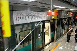
Kaohsiung Arena Station platform.
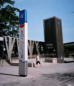
Kaohsiung Arena Station Exit 2.
The station is a two-level, underground station with an island platform and five exits.[2] It is 215 meters long and is located at the intersection of Boai Road and Yucheng Road.[3]
Station layout
| Street Level | Entrance/Exit | Entrance/Exit |
| B1 | Concourse | Lobby, information desk, automatic ticket machines, one-way faregates |
| Restrooms (Near Exits 2 & 4) | ||
| B2 | Platform 1 | ← KMRT Red Line toward Siaogang (Aozihdi) |
| Platform 2 | → KMRT Red Line toward Gangshan South (Ecological District) → | |
Exits
- Exit 1: Sanmin Home Economics & Commerce Vocational High School
- Exit 2: Mingcheng Park
- Exit 3: Sanmin Home Economics & Commerce Vocational High School
- Exit 4: Daba Hotel
- Exit 5: Kaohsiung Arena, Hansheng Arena
Around the Station
- Sanmin Home Economics & Commerce Vocational High School
- Ruifeng Night Market
- Kaohsiung Arena
- Hanshin Department Store
- Mingcheng Park
- Arena Shopping Circle
References
| Wikimedia Commons has media related to Kaohsiung Arena Station. |
- ↑ "統計資訊 > 統計月報". Transportation Bureau, Kaohsiung City Government. Retrieved 2011-02-15.
- ↑ "巨蛋站". 高雄捷運公司. Retrieved 2010-07-10.
- ↑ "巨蛋車站週邊地圖". 高雄市政府捷運工程局. Retrieved 2010-07-10.
Nearby stations
| Preceding station | Kaohsiung MRT | Following station | ||
|---|---|---|---|---|
toward Gangshan South | Red Line | toward Siaogang |
Coordinates: 22°39′58″N 120°18′12″E / 22.66611°N 120.30333°E
This article is issued from Wikipedia - version of the 10/19/2016. The text is available under the Creative Commons Attribution/Share Alike but additional terms may apply for the media files.