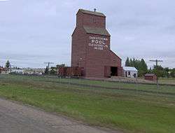
Keatley, Saskatchewan
| Keatley | |
|---|---|
| Unincorporated community | |
 Keatley | |
| Coordinates: 52°48′00″N 107°28′00″W / 52.800000°N 107.466667°W | |
| Country | Canada |
| Province | Saskatchewan |
| Census division | 16 |
| Rural Municipality | Douglas |
| Government | |
| • Governing body | Douglas No. 436 |
| Time zone | CST |
| Area code(s) | 306 |
| Highways |
Highway 13 Highway 18 |
Keatley is an unincorporated community in Douglas Rural Municipality No. 436, Saskatchewan, Canada. The community is located 60 kilometers northeast of the city of North Battleford, Saskatchewan.
See also
References
 |
Mullingar | Alticane | Blaine Lake |  |
| Vidora | |
Krydor | ||
| ||||
| | ||||
| Maymont | Hafford | Waldheim |
Coordinates: 49°23′00″N 109°17′03″W / 49.38333°N 109.28417°W
This article is issued from Wikipedia - version of the 1/6/2015. The text is available under the Creative Commons Attribution/Share Alike but additional terms may apply for the media files.
