Kentucky Route 22
| ||||
|---|---|---|---|---|
 | ||||
| Route information | ||||
| Maintained by KYTC | ||||
| Length: | 112.435 mi[1] (180.947 km) | |||
| Major junctions | ||||
| West end: |
| |||
|
| ||||
| East end: |
| |||
| Location | ||||
| Counties: | Jefferson, Oldham, Henry, Owen, Grant, Pendleton, Bracken | |||
| Highway system | ||||
| ||||

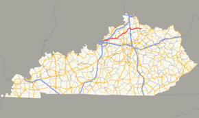
Kentucky Route 22 (KY 22) is a 112.435-mile (180.947 km) east–west highway running from the eastern suburbs of Louisville to an unincorporated place called Willow in Bracken County in Northern Kentucky.
Route 22 has a short 0.332-mile (0.534 km) business route in Dry Ridge, an area which has become a commercial center as an I-75 exit.
It begins at US 42 at the city limit of a Louisville suburb called Northfield, Kentucky, and carries the name Brownsboro Road, a local road which begins near Downtown Louisville. It crosses the Kentucky River west of Gratz and terminates at Kentucky Route 10 in Willow.
Major intersections
| County | Location | mi[1] | km | Destinations | Notes |
|---|---|---|---|---|---|
| Jefferson | Louisville | 0.000 | 0.000 | Western terminus | |
| Brownsboro Road | former KY 22 west | ||||
| 3.696 | 5.948 | ||||
| 4.522 | 7.277 | I-265 exit 34 | |||
| 4.827 | 7.768 | ||||
| Oldham | Pewee Valley | 8.550 | 13.760 | ||
| Crestwood | 9.982 | 16.064 | |||
| 10.230 | 16.464 | West end of KY 146 overlap | |||
| 10.269 | 16.526 | East end of KY 146 overlap | |||
| 10.654 | 17.146 | ||||
| | 12.046 | 19.386 | |||
| Centerfield | 13.854 | 22.296 | West end of KY 393 overlap | ||
| | 14.809 | 23.833 | East end of KY 393 overlap | ||
| | 16.228 | 26.116 | |||
| Ballardsville | 17.766 | 28.592 | West end of KY 53 overlap | ||
| | 18.239 | 29.353 | East end of KY 53 overlap | ||
| Henry | | 21.585 | 34.738 | ||
| | 24.707 | 39.762 | |||
| Eminence | 28.096 | 45.216 | |||
| 28.654 | 46.114 | West end of KY 55 overlap | |||
| 28.756 | 46.278 | East end of KY 55 overlap | |||
| | 30.229 | 48.649 | |||
| | 30.946 | 49.803 | West end of US 421 overlap | ||
| Pleasureville | |||||
| 33.518 | 53.942 | East end of US 421 overlap | |||
| | 36.898 | 59.382 | West end of KY 573 overlap | ||
| Bethlehem | 37.255 | 59.956 | East end of KY 573 overlap | ||
| | 40.390 | 65.001 | |||
| | 45.948 | 73.946 | |||
| Kentucky River | Gratz Bridge | ||||
| Owen | Gratz | 46.644 | 75.066 | West end of KY 355 overlap | |
| 46.861 | 75.415 | East end of KY 355 overlap | |||
| | 50.029 | 80.514 | |||
| | 52.145 | 83.919 | |||
| | 53.741 | 86.488 | |||
| | 54.860 | 88.289 | Davis Lake Road (KY 1670 south) | ||
| Owenton | 55.116 | 88.701 | |||
| 55.553 | 89.404 | Roland Avenue (KY 2354 north) | |||
| 55.801 | 89.803 | West end of US 127 / KY 227 overlap | |||
| East Adair Street (KY 1287 east) | |||||
| 56.365 | 90.711 | East end of US 127 overlap | |||
| | 57.444 | 92.447 | |||
| | 57.950 | 93.261 | |||
| | 60.451 | 97.286 | |||
| Sweet Owen | 61.712 | 99.316 | West end of KY 845 overlap | ||
| | 62.562 | 100.684 | East end of KY 845 overlap | ||
| Needmore | 64.240 | 103.384 | |||
| Grant | Holbrook | 66.088 | 106.358 | ||
| Twin Bridges | 68.934 | 110.939 | |||
| Four Corners | 71.216 | 114.611 | |||
| Dry Ridge | 76.206 | 122.642 | west end of KY 467 overlap | ||
| 76.577 | 123.239 | I-75 exit 159 | |||
| 76.883 | 123.731 | ||||
| 77.291 | 124.388 | West end of US 25 overlap | |||
| 78.485 | 126.309 | east end of KY 467 overlap | |||
| 78.708 | 126.668 | ||||
| Williamstown | |||||
| 80.382 | 129.362 | ||||
| 81.438 | 131.062 | ||||
| 81.625 | 131.363 | East end of US 25 overlap | |||
| 83.277 | 134.021 | ||||
| Pendleton | | 87.358 | 140.589 | ||
| | 95.789 | 154.157 | West end of US 27 overlap | ||
| | 97.741 | 157.299 | |||
| Falmouth | 99.175 | 159.607 | East end of US 27 overlap | ||
| 100.506 | 161.749 | ||||
| | 102.687 | 165.259 | |||
| Bracken | | 109.489 | 176.205 | ||
| Willow | 112.435 | 180.947 | |||
1.000 mi = 1.609 km; 1.000 km = 0.621 mi
| |||||
Dry Ridge business route
| |
|---|---|
| Location: | Dry Ridge |
| Length: | 0.336 mi[1] (0.541 km) |
| Existed: | 2005[2]–present |
Kentucky Route 22 Business (KY 22 Business) is a business route of KY 22 in Dry Ridge. The highway runs 0.336 miles (0.541 km) between junctions with KY 22 and US 25 Business, passing through the heart of Dry Ridge. It was formed in 2005 with the opening of the Dry Ridge Bypass, which rerouted KY 22 around the city.[2]
See also
References
- 1 2 3 "Kentucky Transportation Cabinet - Division of Planning". Retrieved July 15, 2014.
- 1 2 "Dry Ridge bypass may spur business". Retrieved July 16, 2014.