Kerkennah Islands
|
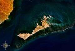
Kerkennah Islands seen from space | |
| Geography | |
|---|---|
| Coordinates | 34°42′N 11°11′E / 34.700°N 11.183°E |
| Area | 160 km2 (62 sq mi) |
| Administration | |
| Demographics | |
| Population | 15,501 (2014) |
Kerkennah Islands (Tunisian Arabic: قرقنة ![]() qarqna) are a group of islands lying off the east coast of Tunisia in the Gulf of Gabès, at 34°42′N 11°11′E / 34.700°N 11.183°E. The Islands are low-lying being no more than 13 metres (43 feet) above sea level. The main islands are Chergui and Gharbi. The archipelago has an area of 160 square kilometres (62 sq mi) and a population of 15,501 (2014).
qarqna) are a group of islands lying off the east coast of Tunisia in the Gulf of Gabès, at 34°42′N 11°11′E / 34.700°N 11.183°E. The Islands are low-lying being no more than 13 metres (43 feet) above sea level. The main islands are Chergui and Gharbi. The archipelago has an area of 160 square kilometres (62 sq mi) and a population of 15,501 (2014).
Kerkennah's main town, Remla (on Chergui) has a population of 2,000. The population of the islands significantly decreased during the 1980s due to drought. The islands were unable to provide suitable irrigation systems and, with clean water rapidly running out, many islanders were forced to leave for mainland Tunisia, the nearest town being Sfax.
History
Kerkennah has a lengthy, but simple history. The natives of Tunisia and Kerkennah originally settled there, but during the spread of the Roman Empire, Kerkennah was used as a port and look-out point by the Romans, to keep note of off-shore activity. In 2 B.C, Augustus exiled Sempronius Gracchus, a lover of Julia the Elder, to the islands for 14 years for his shameful indiscretions with his then married daughter.
Among the Catholic bishops whom the Arian Vandal king Huneric summoned to Carthage in 484, was a Bishop Athenius of Cercina, the seat of the bishopric being in the most easterly island of the group.[1][2] No longer a residential bishopric, Cercina is today listed by the Catholic Church as a titular see.[3]
In 532, Saint Fulgentius of Ruspe built a monastery on one of the islets of the group.[1]
Geography

The islands are warm and dry, with strong prevailing winds. This is mainly due to its positioning in the Gulf of Gabes, with strong sea winds (Gharbi), carried over the mainland, making them hot and dry. What little water vapour there is, is lost over cooler Tunisia first. This causes the general ecology of the island to mainly consist of tall xerophytic (and often halophytic) flora, such as palms and saltbushes.
The land is arid, as if desertification was imminent. There is little agriculture, though the islanders own chickens and goats for their own personal consumption. Fishing, especially for octopus, is also a key industry of Kerkennah, whence it is exported to mainland Tunisia and other nearby countries.
Relative to the mainland and as a result of the lack of tourist-attracting "endless" sandy beaches, tourism is limited in Kerkennah. Many mainland Tunisians spend their holidays in Kerkennah, and many more affluent Tunisians often build private second homes on the island. Tourists also come from European countries. Temperatures on the island are high, with a minimum of 15 °C (59 °F) and often reaching 48 °C (118 °F).
The north includes a port known as Kraten.
See also
References
- 1 2 G.-L. Feuille, v. Cercina, in Dictionnaire d'Histoire et de Géographie ecclésiastiques, vol. XII, Paris 1953, col. 160
- ↑ Stefano Antonio Morcelli, Africa christiana, Volume I, Brescia 1816, pp. 140–141
- ↑ Annuario Pontificio 2013 (Libreria Editrice Vaticana 2013 ISBN 978-88-209-9070-1), p. 866
| Wikimedia Commons has media related to Kerkennah Islands. |
