Kidira
| Kidira | |
|---|---|
| Town | |
 | |
 Kidira | |
| Coordinates: 14°25′N 12°15′W / 14.417°N 12.250°W | |
| Country |
|
| Region | Tambacounda |
| Department | Bakel |
| Population (2013) | |
| • Total | 10,065 |
| Time zone | GMT (UTC+0) |
Kidira is a town and commune in Tambacounda Region of eastern Senegal, lying near the Malian border. Its population in 2013 was about 10,000. [1]
Transport

Kidira view
Falémé River at Kidira
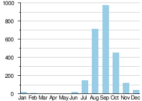
Average monthly flow (m3/s) at the Kidira hydrometric station over the period 1904-1984[2]
It is an important transport hub and lies on the N1 and N2 roads, the Dakar – Bamako railway and the Falémé River.
See also
References
- ↑ http://www.geohive.com/cntry/senegal_ext.aspx
- ↑ Hydrographic data for Kidira, Sénégal 1930-1983, Unesco International Hydrological Programme, retrieved 24 May 2012.
This article is issued from Wikipedia - version of the 11/26/2016. The text is available under the Creative Commons Attribution/Share Alike but additional terms may apply for the media files.