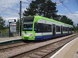
King Henry's Drive tram stop
|
| |
| Location |
Parkway, New Addington, London Borough of Croydon United Kingdom |
| Operated by | Tramlink |
| Platforms | 2 |
| Construction | |
| Disabled access | Yes |
| Other information | |
| Fare zone | London fare zones 3, 4, 5 and 6 |
| History | |
| Opened | 2000 |
| Traffic | |
| Passengers (2009–10) | 0.213 million total boardings and alightings[1] |
| Passengers (2010–11) | 0.243 million total boardings and alightings[2] |
Coordinates: 51°20′44″N 0°01′13″W / 51.345453°N 0.020352°W King Henry's Drive tram stop is a light rail stop serving the Betchworth Way residential area of New Addington, in the London Borough of Croydon in the southern suburbs of London. It is located in the wide central reservation of a dual carriageway.
Services
The tram stop is served by Tramlink route 3, which connects Wimbledon with New Addington via central Croydon.
Connections
London Buses routes 64, 130 and 664 serve the station. Interchange between trams and these bus routes is free in New Addington.[3][4]
Layout
| Eastbound | Route 3 towards New Addington |
| Westbound | Route 3 towards Wimbledon |
| Preceding tram stop | Following tram stop | |||
|---|---|---|---|---|
towards Wimbledon | Route 3 | Terminus |
References
| Wikimedia Commons has media related to King Henry's Drive tram stop. |
- ↑ "Tram Stop Usage 2009-10 (FOI)" (XLS). Tramlink annual passenger performance 2009-2010. Transport for London. 18 August 2011. Retrieved 28 November 2012.
- ↑ "Tramlink numbers 2010-2011" (PDF). Tramlink annual passenger performance 2010-2011. Transport for London. 28 March 2012. Retrieved 28 November 2012.
- ↑ "Buses and trams from New Addington (central)" (PDF). Transport for London. Retrieved 30 August 2016.
- ↑ "King Henry's Drive tram stop – Live bus arrivals and timetables". Transport for London. Retrieved 30 August 2016.
External links
- King Henry's Drive tram stop – Live departures and timetables at Transport for London
This article is issued from Wikipedia - version of the 9/22/2016. The text is available under the Creative Commons Attribution/Share Alike but additional terms may apply for the media files.
