Kingdom of Dalmatia
| Kingdom of Dalmatia | ||||||||||
| Kraljevina Dalmacija Königreich Dalmatien Regno di Dalmazia | ||||||||||
| Crown land of the Austrian Empire and of Cisleithania in Austria-Hungary | ||||||||||
| ||||||||||
| ||||||||||
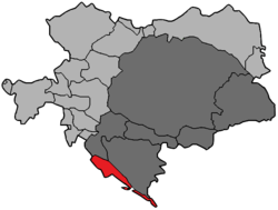
 Dalmatia (red) in Austria-Hungary, 1914 | ||||||||||
| Capital | Zadar | |||||||||
| Languages | Croatian, Italian | |||||||||
| Religion | Roman Catholic | |||||||||
| Government | Constitutional Monarchy | |||||||||
| King | ||||||||||
| • | 1815–1835 | Francis I | ||||||||
| • | 1835–1848 | Ferdinand I | ||||||||
| • | 1848–1916 | Francis Joseph I | ||||||||
| • | 1916–1918 | Charles I | ||||||||
| Governor | ||||||||||
| • | 1815–1831 | Franjo Tomašić (first) | ||||||||
| • | 1911–1918 | Mario Attems (last) | ||||||||
| Legislature | Diet of Dalmatia | |||||||||
| Historical era | New Imperialism / WWI | |||||||||
| • | Congress of Vienna | 22 June 1815 | ||||||||
| • | Independence | 29 October 1918 | ||||||||
| Area | ||||||||||
| • | 1910 | 12,831 km² (4,954 sq mi) | ||||||||
| Population | ||||||||||
| • | 1910 est. | 645,666 | ||||||||
| Density | 50.3 /km² (130.3 /sq mi) | |||||||||
| Currency | Gulden, (1815–1892) Krone (1892–1918) | |||||||||
| ||||||||||
| Today part of | | |||||||||
The Kingdom of Dalmatia (Croatian: Kraljevina Dalmacija, German: Königreich Dalmatien; Italian: Regno di Dalmazia) was a crown land of the Austrian Empire (1815–1867) and the Cisleithanian half of Austria-Hungary (1867–1918). It encompassed the entirety of the region of Dalmatia with its capital at Zadar.
History
Part of a series on the |
|---|
| History of Croatia |
 |
|
Contemporary Croatia |
| Timeline |
|
|
The Habsburg Monarchy had annexed the lands of Dalmatia after the Napoleonic War of the First Coalition: when Napoleon Bonaparte launched his Italian Campaign into the Habsburg duchies of Milan and Mantua in 1796, culminating in the Siege of Mantua, he compelled Emperor Francis II to make peace. In 1797 the Treaty of Campo Formio was signed, whereby the Habsburg emperor renounced possession of the Austrian Netherlands and officially recognized the independence of the Italian Cisalpine Republic. In turn, Napoleon ceded to him the possessions of the Republic of Venice, including the Dalmatian coast (Venetian Dalmatia) and the Bay of Kotor (Venetian Albania). La Serenissima had sided with Austria in order to defend her Domini di Terraferma and was occupied by French troops on 14 May 1797. The treaty ended the centuries-long history of the Venetian Republic.
The newly acquired Habsburg crown land stretched from the Rab Island and Karlobag in the north down the Adriatic coast to Budva in the south, while the Republic of Ragusa (Dubrovnik) retained its independence until 1808. When in 1804 Francis II created the title of Emperor of Austria for himself (as Francis I), he also added that of "King of Dalmatia" (Dalmatiae Rex). However, the possessions were again lost after the Austrian defeat in the Battle of Austerlitz and the 1805 Peace of Pressburg, when they temporarily formed part of the French Illyrian Provinces. Not until the Congress of Vienna in 1814–15 was the Kingdom of Dalmatia formed from the regained territories, now including the former Republic of Ragusa and stretching down to Sutomore in the southeast.
About 1850, the Austrians had the Prevlaka fortress erected to control the maritime traffic in the Bay of Kotor. Upon the Revolutions of 1848, Dalmatia was temporarily under the control of Ban Josip Jelačić of Croatia. However, the Italian-speaking elite dominating the Diet of Dalmatia urged autonomy for the kingdom as an Austrian crown land – against the Croatian national revival movement's demand for a Triune Kingdom of Croatia, Slavonia, and Dalmatia. In the Austro-Hungarian Compromise of 1867, a unification with the Kingdom of Croatia-Slavonia was denied. While Croatia-Slavonia was incorporated into the Lands of the Crown of Saint Stephen, Dalmatia remained a crown land of the Cislethanian (Austrian) half of the Dual Monarchy.
The kingdom was a separate administrative division of Austria-Hungary until 1918, when its territory – except for Zadar, its territory and the island of Lastovo, annexed by the Kingdom of Italy – became part of the State of Slovenes, Croats and Serbs and the Kingdom of Serbs, Croats and Slovenes (later Kingdom of Yugoslavia). As a result of the Vidovdan Constitution (in 1921), the majority of the kingdom was divided into the Split Oblast and Dubrovnik Oblast, with the Bay of Kotor being administratively split off to the largely Montenegrin Zeta Oblast.
Demographic history
1818–1857
According to M. Lorković, the total population of Dalmatia numbered 297,912 in 1818; 326,739 in 1825; 338,599 in 1830; 390,381 in 1840; and 393,715 in 1850.[1][2]
Based on the 1857 census, the Kingdom of Dalmatia had 415,628 inhabitants.[3] According to an analysis of the 1857 census, 318,500 (76.5%) inhabitants were Croats, 77,500 (18.5%) were Serbs, and ca. 20,000 were Italian-speakers (5%).[4] The percentage of Dalmatian Serbs had been 19.9% in the 1830–50 period.[4] In the cities, the inhabitants were 71% Croat, 22% Italian and 7% Serb.[4] There were 745 Serbs in Kotor; in all other cities there were fewer than 400.[4] The number of Serbs in Dalmatia fell; however, in the north it rose.[4] Among the Orthodox, there was one priest for every 400 people, while among the Catholics, there was one priest for every 330 people.[4]
1880
The 1880 Austrian census, recorded the following ethnic groups in the Kingdom:
1900
The 1900 Austrian census:[5]
- 496,966 Catholics
- 96,279 Eastern Orthodox
- 539 Others
By language:[5]
- Serbo-Croatian: 565,276 (95,2%)
- Italian: 15,279 (2,6%)
- German: 2,306 (0,4%)
- Total: 593,784
1910
According to the official 1910 Austrian census, population by religion and mother language was:[6]
- 539,057 Catholics
- 105,332 Orthodox
- 1,257 Others
- Serbo-Croatian: 610,649
- Italian: 18,028
- German: 3,081
- Others: 3,077
Cities
The major cities were (1900):[7]
Districts

.svg.png)
Dalmatia consisted of 13 districts, whose capitals were:
Religion
The Roman Catholic archbishop had his seat in Zadar, while the diocese of Kotor, diocese of Hvar, diocese of Dubrovnik, diocese of Šibenik and diocese of Split were bishoprics. At the head of the Orthodox community stood the bishop of Zadar.
The use of Croatian-Slavonic liturgies written in the Glagolitic alphabet, a very ancient privilege of the Roman Catholics in Dalmatia and Croatia, caused much controversy during the first years of the 20th century. There was considerable danger that the Latin liturgies would be altogether superseded by the Glagolitic, especially among the northern islands and in rural communes, where the Slavonic element is all-powerful. In 1904, the Vatican forbade the use of Glagolitic at the festival of SS. Cyril and Methodius, as likely to impair the unity of Catholicism. A few years previously the Slavonic archbishop Rajcevic of Zara, in discussing the "Glagolitic controversy", had denounced the movement as "an innovation introduced by Panslavism to make it easy for the Catholic clergy, after any great revolution in the Balkan States, to break with Latin Rome."
Governors
Part of a series on the |
|---|
| History of Dalmatia |
 |
|
Antiquity |
|
Early modern period |
|
19th century |
|
20th century |
- Franjo Tomašić (1815–1831)
- Wenzeslau Lilienberg Water (1831–1841)
- Ivan August Turszky (1841–1847)
- Matija Rukavina (1847)
- Josip Jelačić (1848–1859)
- Lazar Mamula (1859–1865)
- Josip Filipović (1865–1868)
- Johann Wagner (1868–1869)
- Gottfried Auersperg (1869)
- Julius Fluk von Leidenkron (1869–1870)
- Gavrilo Rodić (1870–1881)
- Stjepan Jovanović (1882–1885)
- Ludovik Comaro (1885–1886)
- Dragutin Blažeković (1886–1890)
- Emil David (1890–1902)
- Erasmus Handel (1902–1905)
- Nicola Nardelli (1905–1911)
- Mario Attems (1911–1918)
Military
Military units in the kingdom at the start of the First World War:
- Common Army
- 22nd (Dalmatian) Infantry Regiment "Graf von Lacy" (garrison: Spalato/Split)
- Imperial-Royal Landwehr
- Imperial-Royal Mounted Dalmatian State Rifle Division (garrison: Sinj)
- 23rd Imperial-Royal Landwehr Infantry Regiment (garrison: Zara/Zadar)
- 37th Imperial-Royal Landwehr Infantry Regiment (garrison: Gravosa/Gruž)
Politics
Dalmatian Parliament
The Kingdom of Dalmatia held elections to the Parliament of Dalmatia in 1861, 1864, 1867, 1870, 1876, 1883, 1889, 1895, 1901, 1908.
Reichsrat
In the 1907 elections, Dalmatia elected the following representatives to the Reichsrat:[8]
- People's Party
- Ante Dulibić
- Vicko Ivčević
- Frane Ivanišević
- Ante Tresić Pavičić
- Ante Vuković
- Juraj Biankini
- Party of Rights
- Ivo Prodan
- Josip Virgil Perić
- Serb People's Party
- Dušan Baljak
- Miho Bjeladinović
- Independent
In the 1911 elections, Dalmatia elected the following representatives:[8]
- People's Party
- Vicko Ivčević
- Pero Čingrija
- Ante Tresić Pavičić
- Juraj Biankini
- Party of Rights
- Ivo Prodan
- Ante Dulibić
- Ante Sesardić
- Josip Virgil Perić
- Serb People's Party
- Dušan Baljak
- Gjuro Vukotić
- Croatian Popular Progressive Party
- Josip Smodlaka
See also
- Dalmatia
- History of Croatia
- History of Dalmatia
- Kingdom of Croatia (Habsburg)
- Kingdom of Hungary (Habsburg)
- Kingdom of Croatia–Slavonia
- Timeline of Croatian history
- Diet of Dalmatia
References
- ↑ Šime Peričić (1998). Gospodarska povijest Dalmacije od 18. do 20. stoljeća. Matica hrvatska. p. 98.
- ↑ Igor Karaman (2000). Hrvatska na pragu modernizacije, 1750-1918. Naklada Ljevak. p. 151. ISBN 978-953-178-155-8.
- ↑ Statistische übersichten über die bevölkerung und den viehstand von Österreich nach der zählung vom 31. october 1857, p. 49
- 1 2 3 4 5 6 Marino Manini (2001). Zbornik radova s Međunarodnog znanstvenog skupa Talijankska uprava na hrvatskom prostoru i egzodus Hrvata 1918-1943. Hrvatski institut za povijest. p. 312.
- 1 2 Gemeindelexikon der im Reichsrate vertretenen Königreiche und Länder, Bd. 14 Dalmatien, p. 88
- ↑ Spezialortsrepertorium der österreichischen Länder I-XII, Wien, 1915–1919
- ↑ Gemeindelexikon der im Reichsrate vertretenen Königreiche und Länder, Bd. 14 Dalmatien
- 1 2 Dvije pobjede don Ive Prodana na izborima za Carevinsko vijeće u Beču
External links
| Wikimedia Commons has media related to Kingdom of Dalmatia. |
Coordinates: 44°07′00″N 15°13′00″E / 44.1167°N 15.2167°E


