Kirmond le Mire
| Kirmond le Mire | |
 Kirmond le Mire |
|
| OS grid reference | TF189926 |
|---|---|
| – London | 135 mi (217 km) S |
| District | West Lindsey |
| Shire county | Lincolnshire |
| Region | East Midlands |
| Country | England |
| Sovereign state | United Kingdom |
| Post town | Market Rasen |
| Postcode district | LN8 |
| Police | Lincolnshire |
| Fire | Lincolnshire |
| Ambulance | East Midlands |
| EU Parliament | East Midlands |
| UK Parliament | Gainsborough |
|
|
Coordinates: 53°25′01″N 0°12′40″W / 53.416830°N 0.21107°W
Kirmond le Mire is a small village and civil parish in the West Lindsey district of Lincolnshire, England. It is situated on the B1203 road, 6 miles (10 km) east from Market Rasen and 11 miles (18 km) south-west from Grimsby. The population is included in the civil parish of Thoresway.
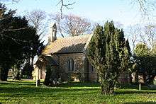
St Martin's church, Kirmond le Mire
Kirmond le Mire Grade II listed Anglican church, built in 1847, is dedicated to St Martin.[1]
The parish includes the lost Medieval settlement of Beckfield.[2]
References
- ↑ Historic England. "Church of St Martin, Kirmond Le Mire (1359767)". National Heritage List for England. Retrieved 21 April 2012.
- ↑ Historic England. "Beckfield (351848)". PastScape. Retrieved 21 April 2012.
External links
 Media related to Kirmond le Mire at Wikimedia Commons
- "Kirmond le Mire", Genuki.org.uk. Retrieved 21 April 2012
England Portal | |
| Unitary authorities | |
| Boroughs or districts | |
| Major settlements |
|
| Topics | |
This article is issued from Wikipedia - version of the 11/8/2016. The text is available under the Creative Commons Attribution/Share Alike but additional terms may apply for the media files.