Regional District of Kootenay Boundary
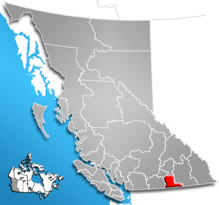
The Regional District of Kootenay Boundary (RDKB) is a regional district in the province of British Columbia, Canada. As of the 2006 census, the population was 30,742. The area is 8,095.62 km² (3,125.74 sq mi). The regional district's offices are in the city of Trail. Other major population centers include the cities of Grand Forks, Rossland, and Greenwood, and the villages of Fruitvale, Warfield, and Montrose.
Municipalities
| Municipality | Government Type | Population |
| Trail | city | 7,681 |
| Grand Forks | city | 3,985 |
| Rossland | city | 3,556 |
| Fruitvale | village | 2,016 |
| Warfield | village | 1,700 |
| Montrose | village | 1,030 |
| Greenwood | city | 708 |
| Midway | village | 674 |
See also
 |
Regional District of Central Okanagan | Regional District of North Okanagan | | |
| Regional District of Okanagan-Similkameen | |
Regional District of Central Kootenay | ||
| ||||
| | ||||
| |
|
|
References
External links
| Subdivisions |  | |
|---|---|---|
| Communities | ||
| Metro areas and agglomerations | ||
| Regional districts |
| |
| ||
Coordinates: 49°30′04″N 117°03′07″W / 49.501°N 117.052°W
This article is issued from Wikipedia - version of the 11/27/2013. The text is available under the Creative Commons Attribution/Share Alike but additional terms may apply for the media files.