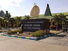
El Tari Airport
| El Tari International Airport Bandar Udara Internasional El Tari | |||||||||||||||
|---|---|---|---|---|---|---|---|---|---|---|---|---|---|---|---|
|
| |||||||||||||||
 | |||||||||||||||
| IATA: KOE – ICAO: WATT | |||||||||||||||
| Summary | |||||||||||||||
| Airport type | Public / Military | ||||||||||||||
| Owner | Government of Indonesia | ||||||||||||||
| Operator | PT Angkasa Pura I | ||||||||||||||
| Serves | Kupang | ||||||||||||||
| Location | Kupang, East Nusa Tenggara, Indonesia | ||||||||||||||
| Elevation AMSL | 102 m / 335 ft | ||||||||||||||
| Coordinates | 10°10′17″S 123°40′16″E / 10.17139°S 123.67111°ECoordinates: 10°10′17″S 123°40′16″E / 10.17139°S 123.67111°E | ||||||||||||||
| Website | kupang-airport.com | ||||||||||||||
| Map | |||||||||||||||
 KOE Location in Timor | |||||||||||||||
| Runways | |||||||||||||||
| |||||||||||||||
| Statistics (2011) | |||||||||||||||
| |||||||||||||||
El Tari International Airport (Indonesian: Bandar Udara Internasional El Tari) (IATA: KOE, ICAO: WATT) is an airport in Kupang, East Nusa Tenggara, Indonesia. The airport is named after El Tari, the governor of East Nusa Tenggara from 1966 to 1978. The airport's ICAO code was changed from WRKK to WATT in 2004.[2] The airport used to serve international routes to Dili and Darwin. This was closed in the 1990s, due to the alleged violation of human rights by the Indonesian Armed Forces in East Timor. The Kupang-Dili route is planned to be resumed as soon as possible, operated by Lion Air.[3]
Airlines and destinations
| Airlines | Destinations |
|---|---|
| Batik Air | Jakarta-Soekarno-Hatta, Jakarta-Halim Perdanakusuma |
| Citilink | Surabaya |
| Garuda Indonesia | Denpasar, Ende, Jakarta–Soekarno–Hatta, Labuan Bajo, Surabaya, Tambolaka |
| Kalstar Aviation | Ende, Maumere, Labuan Bajo, Makassar, Denpasar/Bali |
| Lion Air | Denpasar/Bali, Jakarta-Soekarno-Hatta, Lombok-Mataram (Begins 8 December 2016), Solo, Surabaya, |
| Nam Air | Waingapu, Maumere, Denpasar/Bali |
| Nam Air operated by TransNusa Air Services | Alor, Ende, Ruteng, Bajawa, Lewoleba, Larantuka [4] |
| Sriwijaya Air | Jakarta-Soekarno-Hatta, Surabaya |
| Susi Air | Lewoleba, Sabu |
| TransNusa Air Services | Alor, Bajawa, Denpasar, Ende, Larantuka, Labuan Bajo, Lewoleba, Maumere, Rote, Ruteng, Waingapu |
| Wings Air | Alor, Atambua, Bajawa, Denpasar, Ende, Larantuka, Labuan Bajo, Maumere, Rote, Tambolaka, Waingapu |
Accidents and incidents
- On 27 November 2009, Batavia Air Flight 711, operated by a Boeing 737-400 made an emergency landing after a problem was discovered with the landing gear.[5]
- On 2 December 2009, Merpati Nusantara Airlines Fokker 100 PK-MJD made an emergency landing when the left main gear failed to extend. There were no injuries among the passengers and crew.[5]
- On 10 June 2013, Merpati Nusantara Airlines Flight 6517, a Xian MA60 operated by Merpati Nusantara Airlines suffered a structural failure and crashed on the runway after a hard landing. No one was killed in the crash, but 25 people were injured. 5, including the Captain, was seriously injured. An investigation by the NTSC found that the pilot moved the throttle to the way back, causing the aircraft to lose lift. The crash was the second hull loss of a Xi'an MA60 operated by Merpati.[6]
- On 21 December 2015[7] a Kalstar Aviation Embraer ERJ-195 PK-KDC overshot the runway at El Tari Airport in Kupang.[8]
References
- ↑ Airport information for WATT at World Aero Data. Data current as of October 2006.
- ↑ Kupang-Eltari Airport profile at Aviation Safety Network
- ↑ Mulai 23 Oktober 2016, Lion Air Terbang di Rute Kupang-Dili
- ↑ http://indo-aviation.com/2016/05/17/nam-air-buka-sejumlah-rute-baru-dari-kupang/
- 1 2 "Merpati Air Plane Passengers Unharmed in Emergency Landing". Bernama. Retrieved 4 December 2009.
- ↑ "Merpati Plane Crash-Lands in Kupang: All Survive". 10 June 2013.
- ↑ http://avherald.com/h?article=49124baa
- ↑ "Kalstar E195 incident at Kupang". 21 December 2013.
External links
- Airport information for WATT / KOE at Great Circle Mapper.
- Accident history for WATT / KOE at Aviation Safety Network
This article is issued from Wikipedia - version of the 12/4/2016. The text is available under the Creative Commons Attribution/Share Alike but additional terms may apply for the media files.