La Redonde
 | |
| Geography | |
|---|---|
| Location | Caribbean sea |
| Coordinates | 15°51′04″N 61°35′32″W / 15.85111°N 61.59222°WCoordinates: 15°51′04″N 61°35′32″W / 15.85111°N 61.59222°W |
| Archipelago | Îles des Saintes |
| Total islands | 9 |
| Major islands | Terre-de-Bas Island |
| Administration | |
| Overseas department | Guadeloupe |
| Canton | les Saintes |
| commune | Terre-de-Haut |
| Mayor | Louis Molinié |
| Demographics | |
| Population | uninhabited |
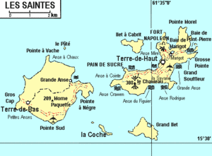
La Redonde (Redonda in English) is an uninhabited rock in the archipelago of Îles des Saintes including the commune (municipality) of Terre-de-Haut. It is located at 150 m (0.093 mi) at South of Terre-de-Haut Island. It is the northern extremity of Grand-Îlet Passage.
The access is very difficult to berth on it, the swell is there constantly bad.[1]
Notes and references
This article is issued from Wikipedia - version of the 11/30/2016. The text is available under the Creative Commons Attribution/Share Alike but additional terms may apply for the media files.