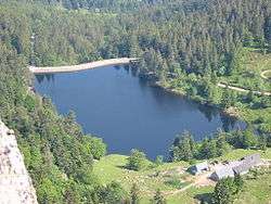
Lac des Truites
| Lac des Truites | |
|---|---|
 | |
| Location | Haut-Rhin |
| Coordinates | 48°06′07″N 7°04′38″E / 48.101944°N 7.077222°E |
| Type | reservoir, glacial |
| Primary outflows | Seebach, a sub-tributary of the Ill |
| Catchment area | 1 km2 (0.39 sq mi) |
| Basin countries | France |
| Surface area | 0.028 km2 (0.011 sq mi) |
| Surface elevation | 1,066 m (3,497 ft) |
Lac des Truites is a lake in the municipality of Soultzeren (Haut-Rhin, France).
Geography
At an elevation of 1066 m, its surface area is 0.028 km². Is the highest lakes of the Vosges massif.[1]
Toponimy
The name of the lake is a mistranslation of the German name Forlenweier. Frenchifying the toponyms of Alsace, the French authorities misread Forle as diminutive of Forelle (in French truite, in English trout[1]) when in fact it is a diminutive of Föhre (pin, pine). The lake has various names, and on maps can be seen as Lac du Forlet.[2]
References
| Wikimedia Commons has media related to Lac des Truites. |
- 1 2 Lac Vert et lac du Forlet, www.randoalsacevosges.com www.alsace-balades.bseditions.fr
- ↑ Pêche au Lac du Forlet (Lac des Truites), www.vallee-munster.eu
This article is issued from Wikipedia - version of the 2/12/2016. The text is available under the Creative Commons Attribution/Share Alike but additional terms may apply for the media files.