Lauricocha Province
| Lauricocha | |
|---|---|
| Province | |
|
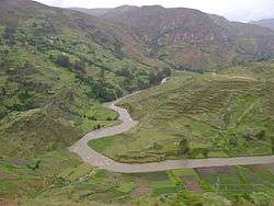
Marañón River in the Lauricocha Province | |
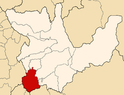
 Location of Lauricocha in the Huánuco Region | |
| Country | Peru |
| Region | Huánuco |
| Capital | Jesús |
| Government | |
| • Mayor | Heriberto Hilarion Estrada Muñoz |
| Area | |
| • Total | 1,860.13 km2 (718.20 sq mi) |
| Population | |
| • Total | 32,626 |
| • Density | 18/km2 (45/sq mi) |
| UBIGEO | 1010 |
Lauricocha Province is one of 11 provinces of the Huánuco Region in Peru. The capital of the province is Jesús.
Location
The province is bordered by the Dos de Mayo Province and the Yarowilca Province in the north, the Huánuco Province and the Ambo Province in the east, the Pasco Region in the south, and the Lima Region and the Ancash Region in the west.
Geography
The Waywash mountain range and the Rawra mountain range traverse the province. The highest peak of the province is Yerupaja. Other mountains are listed below:[1]
- Allqay
- Chakraqucha
- Chawpi Hanka
- Chinkana
- Jirish Hanka
- Kasha
- Kunkan
- Kuntur Wachanan
- Kuntur Waqanan
- Kuraw
- Llamt'a
- Mit'urahu
- Parya
- Pukaqucha
- Puskan T'urpu
- Puywanqucha
- Runtuy
- Siula
- T'uyu Hirka
- Wank'a Marka
- Yana Hirka
- Yarupaqa
Political division
The province is divided in seven districts, which are:
- Baños (Baños)
- Jesús (Jesús)
- Jivia (Jivia)
- Queropalca (Queropalca)
- Rondos (Rondos)
- San Francisco de Asís (Huarin)
- San Miguel de Cauri (Cauri)
Ethnic groups
The province is inhabited by indigenous citizens of Quechua descent. Spanish, however, is the language which the majority of the population (89.48%) learnt to speak in childhood, 10.36% of the residents started speaking using the Quechua language (2007 Peru Census).[2]
See also
Sources
- ↑ escale.minedu.gob.pe - UGEL map of the Lauricocha Province (Huánuco Region)
- ↑ inei.gob.pe INEI, Peru, Censos Nacionales 2007
Coordinates: 10°02′02″S 76°34′55″W / 10.03389°S 76.58194°W
