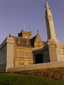
Lerwick Town Hall

Lerwick Town Hall is located in central Lerwick, Shetland, Scotland. It was completed in 1884 during a period of expansion in Lerwick due to the wealth the herring industry brought.[1] It is protected as a Category B listed building.[2]
It was situated at the highest point of Lerwick available facing west to the new town with its back to the old town, lanes and harbour.
It was designed by architect Alexander Ross of Inverness and builder John M. Aitken of Lerwick won the tender at a cost of £3,240. The foundation stone was laid on 24 January 1882 by Prince Alfred (Duke of Edinburgh and second son of Queen Victoria) on a visit to the isles. That same evening Lerwick saw the first ever Up Helly Aa torchlight procession.
The building took 21 months to build and was officially opened on 30 July 1883 (although the building was not complete) by George Thoms, sheriff of Caithness, Orkney and Shetland.[1] The town hall is topped with a clock by Potts of Leeds.
But further work has been done to it in its years. The most recent was the replacement of the front steps which was badly decayed and was replaced just before The Town Hall's 125th Anniversary.
The Town Hall is home to Shetland Islands Council's council chambers and is available to hire for functions and events. Some of The Town Hall's most popular uses are:[3]
- Marriages - in the Main Hall or in the Council Chamber
- Wedding Receptions
- Musical Concerts
- Coffee Mornings/Evenings
- Sales of Work
Inside the building
Inside the building there are some stained glass windows which show many people who have been important in the history of Shetland, Norway and Scotland. The Hamburg Window was meant to tell one of the most interesting stories in the building.
Footnotes
- 1 2 "It cost £4,940 15/6d to build, now monument to civic splendour is 125 | The Shetland Times Ltd". shetlandtimes.co.uk. Retrieved 2014-01-20.
- ↑ "Lerwick Town Hall, Listed Building Report". Historic Scotland. Retrieved 2010-06-01.
- ↑ "Welcome to Shetland Islands Council". shetland.gov.uk. Retrieved 2014-01-20.
Coordinates: 60°9′16″N 1°8′46″W / 60.15444°N 1.14611°W