| Tunnel |
Canal |
Length |
Designer |
Coordinates |
Notes |
Image |
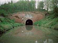
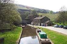
| Ashford Tunnel |
Brecknock and Abergavenny Canal |
375 yards (343 m) |
Thomas Dadford |
51°53.195′N 3°16.525′W / 51.886583°N 3.275417°W / 51.886583; -3.275417 |
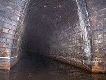
Brecknockshire/Powys Tunnel narrows considerably between northern and southern portals due to repairs to its fabric but is nevertheless navigable by a narrowboat with relative ease. |
 Ashford Tunnel, northern portal |
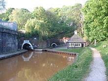
| Blisworth Tunnel |
Grand Union Canal |
3,057 yards (2,795 m) |
|
|
Northamptonshire |
 Blisworth Tunnel, southern portal |
| Braunston Tunnel |
Grand Union Canal |
2,042 yards (1,867 m) |
Jessop & Barnes |
52°16.976′N 1°10.041′W / 52.282933°N 1.167350°W / 52.282933; -1.167350 |
Northamptonshire |
 Narrowboat leaving Braunston Tunnel |
| Bruce Tunnel |
Kennet and Avon Canal |
502 yards (459 m) |
|
|
|
 Bruce Tunnel's Eastern Portal (in 1992) |
| Butterley Tunnel |
Cromford Canal |
|
|
53°3.3841′N 1°22.3994′W / 53.0564017°N 1.3733233°W / 53.0564017; -1.3733233 |
Derbyshire |
 The Butterley Reservoir Adit where it enters the Butterley Tunnel, in 2006 |
| Chirk Tunnel |
Llangollen Canal |
459 yards (420 m) |
|
52°55′46.91″N 3°3′46.77″W / 52.9296972°N 3.0629917°W / 52.9296972; -3.0629917 |
Near Chirk |
|
| Drakeholes Tunnel |
Chesterfield Canal |
154 yards (141 m) |
|
|
|
|
| Dudley Tunnel |
Birmingham Canal Navigations |
|
|
52°31′18″N 2°04′42″W / 52.52173°N 2.07840°W / 52.52173; -2.07840 |
Part of Dudley Canal Line No 1 |
 The southern portal of the Dudley Tunnel |
| Greywell Tunnel |
Basingstoke Canal |
|
|
|
Closed to traffic following cave-in. Now home to Europe's largest bat colony. |
 The eastern portal of Greywell Tunnel on the Basingstoke Canal |
| Hardham Tunnel |
Arun Navigation |
375 yards (343 m) |
|
50°56′56″N 0°31′23″W / 50.94889°N 0.52306°W / 50.94889; -0.52306 |
Closed since 1888; blocked in 1895 by LBSCR under Mid Sussex Line and Midhurst-Pulborough Line. |
| Harecastle Tunnels |
Trent & Mersey Canal |
|
James Brindley/ Thomas Telford |
53°4′27″N 2°14′11″W / 53.07417°N 2.23639°W / 53.07417; -2.23639 |
Staffordshire |
 North ends of both Harecastle Tunnels, Telford's tunnel on the left, Brindley's the right |
| Hollingwood Common Tunnel |
Chesterfield Canal |
|
|
|
|
|
| Lapal Tunnel |
Birmingham Canal Navigations |
|
|
52°26′42″N 2°00′06″W / 52.4450°N 2.0017°W / 52.4450; -2.0017 |
Part of Dudley Canal Line No 2 |
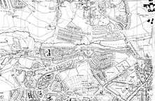 1955 Ordnance Survey map of the east portal of Lapal Tunnel |
| Lord Ward's Tunnel |
Birmingham Canal Navigations |
|
|
|
|
|
| Newbold Tunnel |
Oxford Canal |
|
|
|
|
|
| Norwood Tunnel |
Chesterfield Canal |
2,893 yards (2,645 m) |
|
53°20′06″N 1°16′11″W / 53.33501°N 1.26971°W / 53.33501; -1.26971 |
Derbyshire |
|
| Netherton Tunnel |
Birmingham Canal Navigations |
|
|
52°30′25″N 2°03′25″W / 52.50697°N 2.05708°W / 52.50697; -2.05708 |
|
 Netherton Tunnel |
| Sapperton Canal Tunnel |
Thames and Severn Canal |
3,817 yards (3,490 m) |
|
53°35′29″N 1°57′36″W / 53.591283°N 1.95996°W / 53.591283; -1.95996 |
Gloucestershire |
.jpg) The Coates Portal at the south-eastern end of the Sapperton Canal Tunnel. |
| Scout Tunnel |
Huddersfield Narrow Canal |
|
| Standedge Tunnels |
Huddersfield Narrow Canal |
5,686 yards (5,199 m) |
|
53°35′29″N 1°57′36″W / 53.591283°N 1.95996°W / 53.591283; -1.95996 |
West Yorkshire to Greater Manchester |
 Standedge Tunnel entrance at Marsden |
| Wast Hills Tunnel |
Worcester and Birmingham Canal |
2,726 yards (2,493 m) |
|
52°23′25″N 1°56′24″W / 52.3902°N 1.9400°W / 52.3902; -1.9400 |
West Midlands (county) to Worcestershire |
 Wast Hills Tunnel, southern portal |
| Worsley Navigable Levels |
Bridgewater Canal |
|
|
53°30′2.2″N 2°22′52.2″W / 53.500611°N 2.381167°W / 53.500611; -2.381167 |
Greater Manchester |
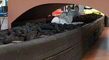 Starvationer at Ellesmere Port Canal Museum with a demonstration of the process of legging to push the boat through the tunnels |

