Name
|
Type
|
Date
|
Condition
|
Image |
Coordinates |
Governorate |
Notes |
| AleppoCitadel of Aleppo |
Castle |
110112–13th centuries |
Partially restored |
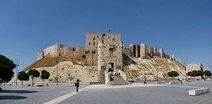 |
36°11′57″N 37°09′45″E / 36.19917°N 37.16250°E / 36.19917; 37.16250 (Citadel of Aleppo) |
Aleppo |
Covers an ancient tell with remains dating back to the 3rd millennium BCE. |
| NajmQal'at Najm |
Hilltop castle |
110112–13th centuries |
Partially restored |
 |
36°33′18″N 38°15′42″E / 36.55500°N 38.26167°E / 36.55500; 38.26167 (Qal'at Najm) |
Aleppo |
Besieged in 1820 by Ottoman forces after a local warlord had sought refuge in the castle.[1] |
| DamascusCitadel of Damascus |
Castle |
100111–13th centuries |
Partially restored |
 |
33°30′42″N 36°18′7″E / 33.51167°N 36.30194°E / 33.51167; 36.30194 (Citadel of Damascus) |
Damascus |
Part of the Ancient City of Damascus World Heritage Site.[2] |
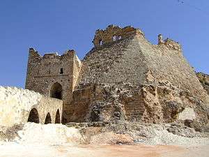
| BosraCitadel of Bosra |
Castle |
|
Partially restored |
.jpg) |
32°31′04″N 36°28′54″E / 32.51778°N 36.48167°E / 32.51778; 36.48167 (Citadel of Bosra) |
Daraa |
Built around a Roman theatre. Part of the Ancient City of Bosra World Heritage Site.[3] |
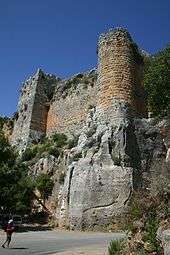
| Halabiye |
Hilltop castle |
05016th century |
Ruins |
|
35°41′22″N 39°49′08″E / 35.68944°N 39.81889°E / 35.68944; 39.81889 (Halabiye) |
Deir ez-Zor |
Originally fortified by Queen Zenobia of Palmyra, refortified under the Byzantine Emperor Justinian I and partially re-used after the Muslim conquest of Syria.[4] |
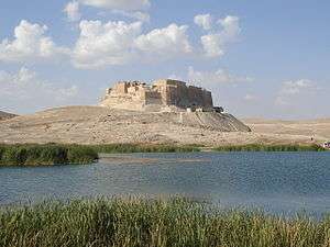
| RahbehQal'at Rahbeh |
Hilltop castle |
|
Ruins |
 |
35°00′18″N 40°25′24″E / 35.00500°N 40.42333°E / 35.00500; 40.42333 (Qal'at Rahbeh) |
Deir ez-Zor |
Much of the current structure dates back to its construction by the Ayyubid lord, Shirkuh II, in 1207. |
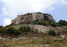
| SukkaraQal'at Sukkara |
Hilltop castle |
|
Ruins |
 |
36°25′38″N 40°23′56″E / 36.42722°N 40.39889°E / 36.42722; 40.39889 (Qal'at Sukkara) |
HasakahAl Hasakah |
Located in the Jebel Abd al-Aziz. |
| Qalʿat Abū Qubais |
Hilltop castle |
|
Partially restored |
 |
35°14′05.9″N 36°19′50.8″E / 35.234972°N 36.330778°E / 35.234972; 36.330778 (Qalʿat Abū Qubais) |
Hama |
|
| Citadel of Hama |
Castle |
|
Ruins |
 |
35°08′10″N 36°44′58″E / 35.13611°N 36.74944°E / 35.13611; 36.74944 (Citadel of Hama) |
Hama |
Excavated by a Danish expedition between 1931 and 1938.[5] |
| Qal'at al-MadiqQalaat al-Madiq |
Hilltop castle |
|
Residential area |
 |
35°25′12″N 36°23′33″E / 35.42000°N 36.39250°E / 35.42000; 36.39250 (Qal'at al-Madiq) |
Hama |
|
| Masyaf Castle |
Spur castle |
|
Partially restored |
 |
35°03′58″N 36°20′36″E / 35.06611°N 36.34333°E / 35.06611; 36.34333 (Masyaf Castle) |
Hama |
|
| Shaizar |
Spur castle |
|
Partially restored |
 |
35°15′55″N 36°33′59″E / 35.26528°N 36.56639°E / 35.26528; 36.56639 (Shaizar) |
Hama |
|
| Citadel of Homs |
Castle |
|
Ruins |
 |
34°43′25″N 36°42′52″E / 34.72361°N 36.71444°E / 34.72361; 36.71444 (Citadel of Homs) |
Homs |
Built on top of an ancient tell with remains dating back to the 3rd millennium BCE.[6] |
| Fakhr-al-Din al-Maani Castle |
Hilltop castle |
|
Partially restored |
 |
34°33′46″N 38°15′25″E / 34.56278°N 38.25694°E / 34.56278; 38.25694 (Fakhr-al-Din al-Maani Castle) |
Homs |
|
| hayr al-gharbiQasr al-Hayr al-Gharbi |
Desert castle |
|
Ruins |
|
34°22′28″N 37°36′21″E / 34.37444°N 37.60583°E / 34.37444; 37.60583 (Qasr al-Hayr al-Gharbi) |
Homs |
|
| hayr al-sharqiQasr al-Hayr al-Sharqi |
Desert castle |
|
Ruins |
 |
35°4′26″N 39°4′16″E / 35.07389°N 39.07111°E / 35.07389; 39.07111 (Qasr al-Hayr al-Sharqi) |
Homs |
|
| Krak des Chevaliers |
Hilltop castle |
|
Partially restored |
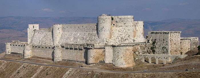 |
34°45′25″N 36°17′4″E / 34.75694°N 36.28444°E / 34.75694; 36.28444 (Krak des Chevaliers) |
Homs |
Part of the Crac des Chevaliers and Qal'at Salah El-Din World Heritage Site.[7] |
| Shmemis |
Hilltop castle |
|
Ruins |
 |
35°02′13″N 37°00′49″E / 35.03694°N 37.01361°E / 35.03694; 37.01361 (Shmemis) |
Homs |
|
| Harem Castle |
Hilltop castle |
|
Ruins |
|
36°12′27″N 36°31′09″E / 36.20750°N 36.51917°E / 36.20750; 36.51917 (Harem Castle) |
Idlib |
|
| Bani Qahtan Castle |
Hilltop castle |
|
Ruins |
|
35°23′44″N 36°09′15″E / 35.39556°N 36.15417°E / 35.39556; 36.15417 (Bani Qahtan Castle) |
Latakia |
|
| Bourzey CastleBourzey castle |
Hilltop castle |
|
Ruins |
 |
35°39′29″N 36°15′39″E / 35.65806°N 36.26083°E / 35.65806; 36.26083 (Bourzey Castle) |
Latakia |
|
| Mahalibeh Castle |
Hilltop castle |
|
Partially restored |
 |
35°30′28″N 36°05′14″E / 35.50778°N 36.08722°E / 35.50778; 36.08722 (Mahalibeh Castle) |
Latakia |
|
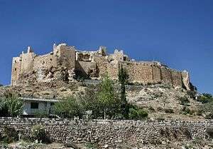
| Salah ed-DinQal'at Salah ed-Din |
Spur castle |
|
Partially restored |
 |
35°35′45″N 36°03′26″E / 35.59583°N 36.05722°E / 35.59583; 36.05722 (Qal'at Salah ed-Din) |
Latakia |
Part of the Crac des Chevaliers and Qal'at Salah El-Din World Heritage Site.[7] |
| Nimrod Fortress |
Hilltop castle |
100113th century |
|
 |
33°15′10″N 35°42′53″E / 33.25278°N 35.71472°E / 33.25278; 35.71472 (Nimrod Fortress) |
Quneitra |
The castle is located in the Golan Heights which is currently under Israeli occupation. |
| RaqqahCitadel of Ar-Raqqah |
Castle |
120113th century |
Destroyed |
|
35°56′4″N 39°00′5″E / 35.93444°N 39.00139°E / 35.93444; 39.00139 (Citadel of Ar-Raqqah) |
RaqqahAr-Raqqah |
The citadel was completely removed and built over in the 1950s.[8] |
| Ja'barQal'at Ja'bar |
Hilltop castle |
110112th century |
Partially restored |
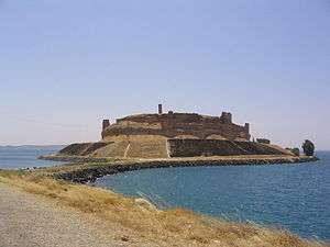 |
35°53′51″N 38°28′51″E / 35.89750°N 38.48083°E / 35.89750; 38.48083 (Qal'at Ja'bar) |
RaqqahAr-Raqqah |
Originally situated on a hilltop overlooking the Euphrates Valley but now turned into an island by the flooding of Lake Assad.[9] |
| Salkhad Castle |
Hilltop castle |
|
Ruins |
|
32°29′38″N 36°42′36″E / 32.49389°N 36.71000°E / 32.49389; 36.71000 (Salkhad Castle) |
Suwayda |
|
| Chastel Blanc |
Hilltop castle |
|
Partially restored |
 |
34°49′14″N 36°07′01″E / 34.82056°N 36.11694°E / 34.82056; 36.11694 (Chastel Blanc) |
Tartus |
|
| Chastel Rouge |
|
|
Partially restored |
 |
34°48′44″N 35°58′14″E / 34.81222°N 35.97056°E / 34.81222; 35.97056 (Chastel Rouge) |
Tartus |
|
| KahfAl-Kahf Castle |
Spur castle |
110112th century |
Ruins |
|
35°02′27″N 36°04′58″E / 35.04083°N 36.08278°E / 35.04083; 36.08278 (Al-Kahf Castle) |
Tartus |
In 1192, Rashid ad-Din Sinan, also known as the Old Man of the Mountain, died in Al-Kahf Castle, which was an Ismaili stronghold during the 12th century.[10] |
| Qala'at Khawabi |
Spur castle |
|
Residential area |
|
34°58′22″N 36°00′06″E / 34.97278°N 36.00167°E / 34.97278; 36.00167 (Qala'at Khawabi) |
Tartus |
|
| Margat |
Spur castle |
100111–12th centuries |
Partially restored |
 |
35°09′08″N 35°57′0″E / 35.15222°N 35.95000°E / 35.15222; 35.95000 (Margat) |
Tartus |
Headquarters of the Knights Hospitaller in Syria. |
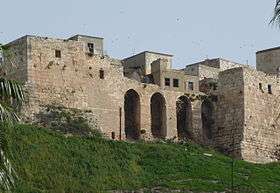
| TartusCitadel of Tartus |
Castle |
|
Residential area |
 |
34°53′36″N 35°52′35″E / 34.89333°N 35.87639°E / 34.89333; 35.87639 (Citadel of Tartus) |
Tartus |
|
|