| Image |
Title / individual commemorated |
Location |
Date |
Sculptor |
Source |
Coordinates |
|---|
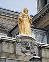 |
Queen Anne |
Market House, Kingston upon Thames |
1706 |
Francis Bird |
[1] |
51°24′35″N 0°18′23″W / 51.40974°N 0.30629°W / 51.40974; -0.30629 |
 |
Shrubsole !Memorial to Henry Shrubsole |
Kingston Market Place |
1882 |
Francis Williamson |
[2] |
51°24′34″N 0°18′23″W / 51.40937°N 0.30626°W / 51.40937; -0.30626 |
 |
Kings Mural |
Eden Street, Kingston upon Thames |
1985 |
Maggie Humphry |
[3] |
51°24′33″N 0°18′12″W / 51.40918°N 0.30347°W / 51.40918; -0.30347 |
 |
Muybridge Mosaic |
Castle Street, Kingston upon Thames |
|
Nicola Benge + volunteers + schoolchildren |
|
51°24′39″N 0°18′07″W / 51.41083°N 0.30194°W / 51.41083; -0.30194 |
 |
Out of Order |
Old London Road, Kingston upon Thames |
1988 |
David Mach |
|
51°24′39″N 0°18′02″W / 51.41083°N 0.30046°W / 51.41083; -0.30046 |
 |
River Celebration |
Old London Road at the Junction of Queen Elizabeth Road, Kingston upon Thames |
1989 |
Carole Hodgson |
[4] |
51°24′38″N 0°17′50″W / 51.410629°N 0.297327°W / 51.410629; -0.297327 |
| |
Study of Hundertwasser |
Skerne Road & Canbury Passage, Kingston |
2005 |
Nicola Benge + 1800 people |
[5] |
51°24′48″N 0°18′17″W / 51.41324°N 0.30478°W / 51.41324; -0.30478 |
|
Kingston Coat of Arms (three fishes) |
London Road, Kingston |
1980 |
David Wynne |
[6] |
51°24′38″N 0°17′40″W / 51.41042°N 0.29455°W / 51.41042; -0.29455 |
|
Chessington Mosaic, depicting St. Mary's Church, the parish church of Chessington |
Clarence Street, near junction with Wood Street, Kingston upon Thames |
1992 |
|
|
51°24′39″N 0°18′20″W / 51.41092°N 0.30557°W / 51.41092; -0.30557 |
|
Surbiton Mosaic, depicting the winged lion crest from the coat of arms of the former Borough of Surbiton |
Clarence Street, at junction with Thames Street, Kingston upon Thames |
1992 |
|
|
51°24′39″N 0°18′18″W / 51.41085°N 0.30501°W / 51.41085; -0.30501 |
|
Kingston Mosaic, depicting the three fishes from the coat of arms of the Royal Borough of Kingston upon Thames |
Clarence Street, at junction with Fife Road, Kingston upon Thames |
1992 |
|
|
51°24′39″N 0°18′14″W / 51.41088°N 0.30391°W / 51.41088; -0.30391 |
|
Old Malden Mosaic, depicting the cross and chevrons from the coat of arms of the former Borough of Malden and Coombe |
Clarence Street, Kingston upon Thames |
1992 |
|
|
51°24′39″N 0°18′12″W / 51.41079°N 0.30344°W / 51.41079; -0.30344 |
|
New Malden Mosaic, depicting a beehive, the historic symbol of the district |
Clarence Street, Kingston upon Thames |
1992 |
|
|
51°24′39″N 0°18′11″W / 51.41072°N 0.30293°W / 51.41072; -0.30293 |
|
Coombe Mosaic, depicting the heraldic fountain from the coat of arms of the former Borough of Malden and Coombe |
Fife Road, Kingston upon Thames |
1992 |
|
|
51°24′41″N 0°18′14″W / 51.41144°N 0.30382°W / 51.41144; -0.30382 |
 |
Paper Trail |
College Roundabout, Kingston |
2012 |
Michael Antrobus and Tom Kean |
[7] |
51°24′25″N 0°18′14″W / 51.40704°N 0.30396°W / 51.40704; -0.30396 |
|
Sopwith Camel propeller |
Canbury |
|
|
[8] |
51°24′48.4″N 0°17′51.2″W / 51.413444°N 0.297556°W / 51.413444; -0.297556 |
.jpg) |
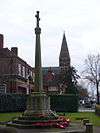
Kingston War Memorial |
Union Street, Kingston |
1920 |
Richard Reginald Goulden |
[9] |
51°24′37″N 0°18′17″W / 51.41038°N 0.30486°W / 51.41038; -0.30486 |
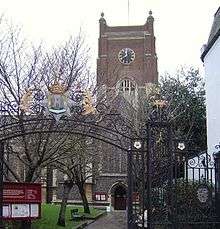 |
East Surrey Regiment memorial gateway |
North side of Market Square, Kingston, leading to All Saints Church |
1920s |
|
[10] |
51°24′36″N 0°18′22″W / 51.41°N 0.3061°W / 51.41; -0.3061 |
| |
Mosaic |
John Lewis, Kingston |
2010 |
Yasha Shrimpton, Howard Grange, members of staff, Save the World Club |
[11][12] |
51°24′41.09″N 0°18′28.31″W / 51.4114139°N 0.3078639°W / 51.4114139; -0.3078639 |
| |
Mosaics |
Kingsnympton Estate |
2004 |
Save The World Club + ~140 children and adults |
[13][14] |
51°25′15.53″N 0°16′45.79″W / 51.4209806°N 0.2793861°W / 51.4209806; -0.2793861 |
|
John the Baptist faces, the Lamb and Flag, scallop shell, and figures as supporters |
Halifax, 86–88 Eden Street, Kingston, over entrances |
20th century |
|
[15] |
51°24′37″N 0°18′07″W / 51.4104°N 0.30203°W / 51.4104; -0.30203 |
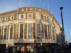 |
Benthall coat of arms |
Façade of Bentall Centre, Clarence Street, Kingston |
1930-2 |
Sir Aston Webb |
[16] |
51°24′40″N 0°18′20″W / 51.41112°N 0.30557°W / 51.41112; -0.30557 |


 Media related to Sculptures in the Royal Borough of Kingston upon Thames at Wikimedia Commons