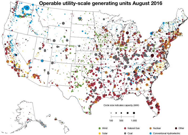
List of the largest coal power stations in the United States
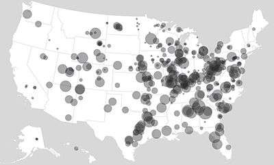
Coal power plants map
This article lists the largest coal power stations in the United States, in terms of Nameplate capacity.
| Station | State | Location | Capacity
in MW |
|---|
| Robert W Scherer Power Plant | .svg.png) Georgia (U.S. state) Georgia (U.S. state) | 33°03′08″N 83°48′25″W / 33.05222°N 83.80694°W / 33.05222; -83.80694 (Robert W Scherer Power Plant) | 3,520 |
| Gibson Generating Station |  Indiana Indiana | 38°22′19″N 87°46′02″W / 38.37194°N 87.76722°W / 38.37194; -87.76722 (Gibson Generating Station) | 3,340 |
| Monroe Power Plant |  Michigan Michigan | 41°53′21″N 83°20′44″W / 41.88917°N 83.34556°W / 41.88917; -83.34556 (Monroe Power Station) | 3,280 |
| Bowen Power Station | Georgia (U.S. state) | 34°07′23″N 84°55′13″W / 34.12306°N 84.92028°W / 34.12306; -84.92028 (Bowen Power Station) | 3,202 |
| John E. Amos Power Plant |  West Virginia West Virginia | 38°28′29″N 81°49′16″W / 38.47472°N 81.82111°W / 38.47472; -81.82111 (John Amos Power Station) | 2,933 |
| J. H. Miller Power Station [1] |  Alabama Alabama | 33°37′57″N 87°03′30″W / 33.63250°N 87.05833°W / 33.63250; -87.05833 (J.H. Miller Power Station) | 2,822 |
| W. A. Parish Power Station [2] |  Texas Texas | 29°28′38″N 95°38′03″W / 29.47722°N 95.63417°W / 29.47722; -95.63417 (W. A. Parish Power Station) | 2,697 |
| Cumberland Power Plant |  Tennessee Tennessee | 36°23′29″N 87°39′17″W / 36.39139°N 87.65472°W / 36.39139; -87.65472 (Cumberland Power Station) | 2,600 |
| Gavin Power Plant |  Ohio Ohio | 38°56′09″N 82°07′00″W / 38.93583°N 82.11667°W / 38.93583; -82.11667 (Gavin Power Plant) | 2,600 |
| Rockport Power Plant | Indiana | 37°55′32″N 87°02′02″W / 37.92556°N 87.03389°W / 37.92556; -87.03389 (Rockport Power Station) | 2,600 |
| Paradise Fossil Plant |  Kentucky Kentucky | 37°15′0″N 86°58′12″W / 37.25000°N 86.97000°W / 37.25000; -86.97000 (Paradise Fossil Plant) | 2,558 |
| Roxboro Power Station [3] |  North Carolina North Carolina | 36°29′06″N 79°04′19″W / 36.48500°N 79.07194°W / 36.48500; -79.07194 (Roxboro Power Station) | 2,558 |
| W. H. Sammis Power Plant | Ohio | 40°31′48″N 80°37′50″W / 40.53000°N 80.63056°W / 40.53000; -80.63056 (W. H. Sammis Power Plant) | 2,456 |
| J. M. Stuart Power Station | Ohio | 38°42′09″N 83°49′17″W / 38.70250°N 83.82139°W / 38.70250; -83.82139 (J.M. Stuart Power Station) | 2,441 |
| Navajo Generating Station |  Arizona Arizona | 36°54′12″N 111°23′25″W / 36.90333°N 111.39028°W / 36.90333; -111.39028 (Navajo Power Station) | 2,409 |
| Sherburne County Generating Station |  Minnesota Minnesota | 45°22′43″N 93°53′48″W / 45.37861°N 93.89667°W / 45.37861; -93.89667 (Sherburne County Generating Station) | 2,400[4] |
| Martin Lake Power Station [5] | Texas | 32°15′36″N 94°34′08″W / 32.26000°N 94.56889°W / 32.26000; -94.56889 (Martin Lake Power Station) | 2,380 |
| Belews Creek Power Station | North Carolina | 36°16′53″N 80°03′37″W / 36.28139°N 80.06028°W / 36.28139; -80.06028 (Belews Creek Power Station) | 2,160 |
| E. C. Gaston Power Station [6] | Alabama | 33°14′37″N 86°27′37″W / 33.24361°N 86.46028°W / 33.24361; -86.46028 (E.C. Gaston Power Station) | 2,013 |
| Homer City Generating Station |  Pennsylvania Pennsylvania | 40°30′39″N 79°11′37″W / 40.51083°N 79.19361°W / 40.51083; -79.19361 (Homer City Generating Station) | 2,012 |
See also
References